Kouba (Algeria)
| Kouba | ||
|---|---|---|
|
|
||
| Coordinates | 36 ° 44 '1 " N , 3 ° 5' 11" E | |

|
||
| Symbols | ||
|
||
| Basic data | ||
| Country | Algeria | |
| Algiers | ||
| ISO 3166-2 | DZ-16 | |
| surface | 16 km² | |
| Residents | 104,708 (2008) | |
| density | 6,544.3 Ew. / km² | |
| politics | ||
| mayor | Mokhtar Laadjailia | |
| Political party | FLN | |
|
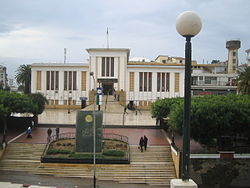
Town Hall (2010)
|
||
Kouba ( Arabic القبة, DMG al-Qubba ) is a municipality in the province of Algiers . It is located southeast of the Algerian capital Algiers and had around 104,708 inhabitants at the 2008 census.
The RC Kouba football club , which plays in the Algerian second division , is based in Kouba .
Kouba got its name from the dome (Kobba) of the mosque that El-Hadj Pacha had built in 1545. On December 31, 1856, Kouba became a parish .
Daughters and sons of the place
- Fernand Sastre (1923–1998), football official
Web links
Commons : Kouba - collection of images, videos and audio files
Individual evidence
- ↑ Recensement 2008 de la population algérienne, wilaya d'Alger, sur le site de l'ONS.
- ^ Journal officiel de la République Algérienne du 19/12/1984, p. 1516, délimitation du territoire de la commune de Kouba.
- ^ The population of the provinces and communes in Algeria by census years , on citypopulation.de. Retrieved October 5, 2018.
- ^ Revue africaine: journal des travaux de la Société Historique Algérienne, Volume 14, 1870, pp. 291/292 [1]
- ↑ Indicateur général de l'Algérie, renfermant la description geographique, statistique et historique de chacune des localités des trois provinces, suivi d'un recueil d'arrêtés et d'un annuaire pour 1848 par Victor Bérard, édition Bastide (Alger), p 199


