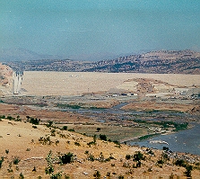
Kralkızı Dam
| Kralkızı Dam | |||||||||||
|---|---|---|---|---|---|---|---|---|---|---|---|
|
|||||||||||
|
|
|||||||||||
| Coordinates | 38 ° 20 '52 " N , 40 ° 1' 15" E | ||||||||||
| Data on the structure | |||||||||||
| Lock type: | Rock embankment dam with a clay core | ||||||||||
| Construction time: | 1985-1998 | ||||||||||
| Height above valley floor: | 113 m | ||||||||||
| Height of the structure crown: | 819 m | ||||||||||
| Building volume: | 15.7 million m³ | ||||||||||
| Crown length: | 1 030 m | ||||||||||
| Crown width: | 12 m | ||||||||||
| Base width: | 550 m | ||||||||||
| Power plant output: | 94 MW | ||||||||||
| Operator: | Devlet Su İşleri (DSİ) | ||||||||||
| Data on the reservoir | |||||||||||
| Water surface | 58 km² | ||||||||||
| Reservoir length | 26 km | ||||||||||
| Storage space | 1919 million m³ | ||||||||||
| Catchment area | 1 300 km² | ||||||||||
The Kralkızı Dam ( Turkish Kralkızı Barajı ) is located on the southern flank of the Southeast Taurus in the Turkish province of Diyarbakır .
The Kralkızı dam was built in 1985-1998 for the purpose of generating energy and dams the Çayı maggots , the right source river of the Tigris . The barrier structure is a 1030 m long stone embankment dam with a clay core . The dam has a height of 113 m above the valley floor and a volume of 15.7 million m³. The associated reservoir extends in the west to the neighboring province of Elazığ . It covers an area of 58 km². The storage space is 1919 million m³. The Kralkızı Dam hydropower plant has two 47 MW Francis turbines . The standard work capacity is 146 GWh per year. Downstream is the Dicle Dam .

