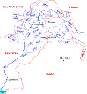
Kundar
| Kundar | ||
|
Location of Kundar in the river system of the Indus |
||
| Data | ||
| location |
Balochistan ( Pakistan ), Paktika ( Afghanistan ) |
|
| River system | Indus | |
| Drain over | Gomal → Indus → Indian Ocean | |
| Headwaters | 130 km northeast of Quetta 31 ° 8 ′ 12 ″ N , 67 ° 51 ′ 8 ″ E |
|
| muzzle |
Gomal coordinates: 31 ° 55 ′ 32 " N , 69 ° 19 ′ 49" E 31 ° 55 ′ 32 " N , 69 ° 19 ′ 49" E
|
|
| length | approx. 200 km | |
| Left tributaries | Sands-Chwara | |
The Kundar is a right tributary of the Gomal in Pakistan and along the border with Afghanistan .
The Kundar rises 130 km northeast of Quetta in the north of the Pakistani province of Balochistan . The river flows through a mountainous desert landscape not far from the Afghan border. It initially flows in an east-northeast direction, later in a northeast direction through a high valley flanked by mountain ranges. After about 130 km he reaches the border with Afghanistan. Shortly before that, the Sande-Chwara flows into the Kundar on the left. This now forms the state border between Afghanistan in the west and Pakistan in the east for the remaining 70 km. The Kundar has a length of about 200 km. Part of its water is used to irrigate the surrounding agricultural areas.
