Gomal
|
Gomal Gumal |
||
| Data | ||
| location | Paktika ( Afghanistan ), Federally Administered Tribal Areas , Khyber Pakhtunkhwa ( Pakistan ) | |
| River system | Indus | |
| Drain over | Indus → Indian Ocean | |
| Headwaters | in Sar Hawza district , Paktika province | |
| muzzle | south of Dera Ismail Chan in the Indus Coordinates: 31 ° 36 ′ 53 " N , 70 ° 50 ′ 46" E 31 ° 36 ′ 53 " N , 70 ° 50 ′ 46" E
|
|
| length | 400 km | |
| Left tributaries | Wana Toi | |
| Right tributaries | Kundar , Zhob | |
| Reservoirs flowed through | Gomal Zam Dam | |
|
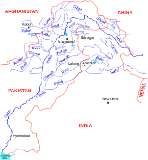
Location of the Gomal in the river system of the Indus |
||
The Gomal (also Gumal , Pashto / Dari گومل رود Gōmal rūd, Urdu دریائے گومل daryā-e Gwmal ) is a river in Afghanistan and Pakistan , which flows into the Indus on the right side .
course
The source of the Gomal is in the north of the Paktika province in the Sar Hawza district . From there it crosses the entire province in a south-easterly direction. At the Pakistani border, the course changes to the east. In Pakistan, Kundar , Wana Toi and Zhob are among the most important tributaries of the Gomal. About 30 kilometers south of the city of Dera Ismail Khan it flows into the Indus. The river has a length of almost 400 kilometers.
At Khjori Kach at the confluence of the Gomal and Zhob rivers, the Gomal-Zam dam was built in 2001–2011 . This includes a 133 m high concrete dam ( RCC dam ) and a 17.4 MW hydropower plant. At the site of the dam of Gomal breaks through the hills of Sulaimangebirges and reached the Indus lowlands .
Web links
- Gomal in the Encyclopædia Iranica (English)
- Map of Paktika (PDF; 300 kB)

