Zhob
| Zhob | ||
| Data | ||
| location | Balochistan , Khyber Pakhtunkhwa ( Pakistan ) | |
| River system | Indus | |
| Drain over | Gomal → Indus → Indian Ocean | |
| Headwaters | Berg chain Kan Metarzai 30 ° 40 '1 " N , 67 ° 34' 4" O |
|
| muzzle |
Gomal-Zam Dam Coordinates: 32 ° 2 '27 " N , 69 ° 49' 39" E 32 ° 2 '27 " N , 69 ° 49' 39" E
|
|
| length | approx. 400 km | |
| Left tributaries | Shinar Khwara , Zarai , Kandil Rud | |
| Small towns | Zhob | |
| Communities | Muslim Bagh | |
|
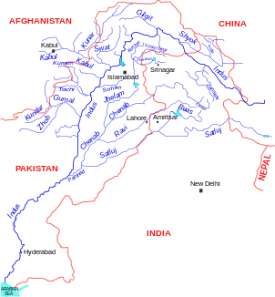
Location of the Zhob in the river system of the Indus |
||
The Zhob is a right tributary of the Gomal in western Pakistan .
The Zhob has its source in the Kan Metarzai mountain range in the north of the Pakistani province of Balochistan . It flows through the village of Muslim Bagh and then turns to the east and later to the north. The Zhob flows through a wide high valley in which desert vegetation prevails. It takes on several tributaries that reach it via alluvial cones . The Zhob flows about 5 km west of the small town of the same name Zhob . Between Muslim Bagh and Zhob, national road 50 follows the course of the Zhob. This usually runs at a distance of approx. 50 km from the Afghan border. The last 10 km before its confluence with the Gomal dammed by the Gomal-Zam dam , the Zhob forms the border with the province of Khyber Pakhtunkhwa . The zhob has a length of about 400 km. Part of its water is used to irrigate the surrounding agricultural areas.

