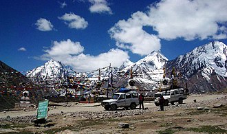
Kunzum Pass
| Kunzum Pass | |||
|---|---|---|---|
|
|
|||
| Compass direction | southwest | Northeast | |
| Pass height | 4550 m | ||
| District | Lahaul and Spiti ( Himachal Pradesh State , India ) | ||
| Watershed | Chandra | Spiti | |
| Valley locations | Khoksar | Lossar | |
| expansion | Pass road | ||
| Mountains | Himalayas | ||
| Map (Himachal Pradesh) | |||
|
|
|||
| Coordinates | 32 ° 23 '40 " N , 77 ° 38' 5" E | ||
The Kunzum Pass (also Kunzum La ) crosses the Western Himalayas in the Indian state of Himachal Pradesh .
A road connection leads from the upper reaches of the Chandra in the south-west to the hospital in the north-east over the Kunzum Pass, which is 4550 m high . The pass road thus connects the western part ( Lahaul ) with the eastern part of Spiti in the Lahaul and Spiti district . There is a temple complex not far from the top of the pass.
Web links
Commons : Kunzum-Pass - collection of pictures, videos and audio files

