Kwadacha River
| Kwadacha River | ||
|
|
||
| Data | ||
| location | British Columbia (Canada) | |
| River system | Mackenzie River | |
| Drain over | Finlay River → Peace River → Slave River → Mackenzie River → Arctic Ocean | |
| Headwaters |
Muskwa Ranges 57 ° 34 ′ 39 ″ N , 124 ° 34 ′ 0 ″ W. |
|
| muzzle | east of Fort Ware in the Finlay River Coordinates: 57 ° 25 ′ 1 ″ N , 125 ° 36 ′ 15 ″ W 57 ° 25 ′ 1 ″ N , 125 ° 36 ′ 15 ″ W
|
|
| length | approx. 100 km | |
| Catchment area | 2410 km² | |
| Discharge at the gauge at Fort Ware A Eo : 2410 km² |
MQ 1960/1998 Mq 1960/1998 |
51 m³ / s 21.2 l / (s km²) |
| Right tributaries |
North Kwadacha River , Warneford River |
|
|
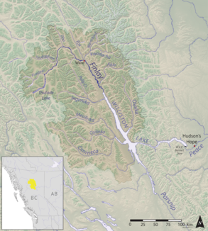
Location of the Kwadacha River |
||
The Kwadacha River is a left tributary of the Finlay River in the north of the Canadian province of British Columbia .
The Kwadacha River rises in the Muskwa Ranges , the northernmost section of the Rocky Mountains . Initially it flows in a westerly direction, later to the southwest. It flows east of Fort Ware into the Finlay River, the northern headwaters of the Peace River . The Kwadacha River has a length of about 100 km. It drains an area of 2410 km². The mean discharge is 51 m³ / s. Important tributaries are the North Kwadacha River and Warneford River , both from the right.
Web links
- Kwadacha River . In: BC Geographical Names (English)
Individual evidence
- ↑ a b Kwadacha River at the gauge near Fort Ware - hydrographic data from R-ArcticNET
