Finlay River
| Finlay River | ||
|
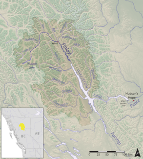
Original catchment area of the Finlay River |
||
| Data | ||
| location | British Columbia ( Canada ) | |
| River system | Mackenzie River | |
| Drain over | Peace River → Slave River → Mackenzie River → Arctic Ocean | |
| origin |
Thutade Lake 57 ° 4 ′ 36 ″ N , 126 ° 53 ′ 2 ″ W. |
|
| Source height | 1200 m | |
| muzzle | in the Finlay Reach of Williston Lake Coordinates: 56 ° 54 ′ 13 " N , 124 ° 57 ′ 2" W 56 ° 54 ′ 13 " N , 124 ° 57 ′ 2" W. |
|
| Mouth height | 660 m | |
| Height difference | 540 m | |
| Bottom slope | 1.3 ‰ | |
| length | 402 km | |
| Catchment area | approx. 22,000 km² (originally 43,000 km²) | |
| Discharge at the Ware A Eo gauge : 11,100 km² |
MQ 1960/1983 Mq 1960/1983 |
190 m³ / s 17.1 l / (s km²) |
| Discharge at the gauge above Akie River A Eo : 16,000 km² |
MQ 1978/2000 Mq 1978/2000 |
263 m³ / s 16.4 l / (s km²) |
| Drain |
MQ |
680 m³ / s |
| Left tributaries | Firesteel River , Kwadacha River , Akie River , Paul River , Fox River | |
| Communities | Fort ware | |
The Finlay River is a 402 km long river in North American Canada in British Columbia .
The river, originally named Finlay's Branch , is named after the explorer and fur trader John Finlay . He traveled the river in 1797 after participating in the Alexander MacKenzie expedition in 1793 for the first crossing of North America north of Mexico .
River course
The river, which belongs to the river system of the Mackenzie River , rises directly east of the continental divide in the Cassiar Mountains and flows from there initially in an easterly direction, later in a south-southeast direction to Williston Lake ; this is drained by the Peace River .
All of this takes place in a huge, almost deserted high mountain area, through which there is still no road. It is only inhabited by a few Indians in small settlements . The catchment area of the Finlay River originally comprised 43,000 km². With the construction of the W. A. C. Bennett Dam and the creation of the Williston Lake Reservoir, the river length and the area of the catchment area have decreased significantly. The latter now measures around 22,000 km².
The actual headwaters of the Mackenzie
Of all the tributaries of the Mackenzie River , the source of the Finlay River is furthest from the Mackenzie Estuary on the Beaufort Sea. Therefore, the Finlay River, which is by far not the longest tributary or tributary of the Mackenzie River, can be regarded as its actual source river. It thus forms the Finlay – Peace – Slave – Mackenzie river.
Web links
- Finlay River . In: BC Geographical Names (English)
Individual evidence
- ^ A b The Atlas of Canada - Rivers
- ↑ Finlay River at the Ware gauge - hydrographic data from R-ArcticNET
- ↑ Finlay River at the gauge above Akie River - hydrographic data from R-ArcticNET
