Akie River
| Akie River | ||
| Data | ||
| location | British Columbia (Canada) | |
| River system | Mackenzie River | |
| Drain over | Finlay River → Peace River → Slave River → Mackenzie River → Arctic Ocean | |
| Headwaters |
Muskwa Ranges 57 ° 32 ′ 31 ″ N , 124 ° 22 ′ 51 ″ W. |
|
| muzzle | in the Finlay River coordinates: 57 ° 1 '43 " N , 125 ° 7' 7" W 57 ° 1 '43 " N , 125 ° 7' 7" W. |
|
| Mouth height | approx. 680 m
|
|
| length | approx. 100 km | |
| Discharge at the gauge near the 760 m line A Eo : 1700 km² |
MQ 1981/2000 Mq 1981/2000 |
32 m³ / s 18.8 l / (s km²) |
|
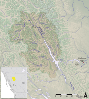
Location of the Akie River |
||
The Akie River is a left tributary of the Finlay River in the north of the Canadian province of British Columbia .
The Akie River has its source in the Muskwa Ranges , the northernmost section of the Rocky Mountains . It initially flows about 25 km south, then turns west and continues its course for another 40 km through the mountains. In the lower reaches of the Akie River flows first to the south-southeast and finally to the south-southwest, before it flows into the Finlay River, the northern headwaters of the Peace River , about 25 km before its mouth in Williston Lake . The Akie Range runs south of the lower reaches. The Akie River is approximately 100 km in length. Its mean discharge at the gauge near the 760 m line is 32 m³ / s.
Web links
- Akie River . In: BC Geographical Names (English)
Individual evidence
- ↑ Akie River at the gauge near the 760 m line - hydrographic data from R-ArcticNET

