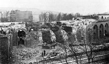
Löhrtor barracks
The Löhrtor barracks , originally called the Löhr Casemate Corps, was a barracks in Koblenz . It was built from 1820 to 1823 as part of the Prussian city fortifications of Koblenz and was therefore part of the fortress of Koblenz and Ehrenbreitstein .
Building description
The basic features of the Löhrtor barracks corresponded to the neighboring Mainzertor barracks . The entire system was 138 meters long. It consisted of a central building, which formed the actual Löhrtor, with an adjoining two-story casemate corps, each 34 meters long, on both sides. The corps ended with a casemate wing , which also served as a moat . The facility was preceded by a dry ditch as an approach obstacle, which could be crossed by means of a wooden and later an iron bridge.
history
The Löhrtor barracks were occupied with troops for the first time in 1823; the later 1st Rhenish Pioneer Battalion No. 8 was initially housed here. In 1878 and 1881, rifle and cannon loopholes on the barracks were replaced by windows, and in 1885 the gate passage was expanded. After the city fortifications were abandoned in 1890, the city of Koblenz was able to purchase the entire complex on November 13, 1898. She had the east wing of the barracks demolished a month later. The city sold the west wing to the parish Herz-Jesu, which had the building demolished in 1899. The stone material obtained was used in the construction of the foundation of the Sacred Heart Church . In May 1900 the Löhrtor and the associated barracks were completely removed. Today the intersection of Löhrstraße and Friedrich-Ebert-Ring is located at the location of the Löhrtor.
literature
- City Archives Koblenz: (StAK) DB 8 Military, 01 City wall with bridges: Löhrtor, Löhrtor barracks (defensive barracks).
- Klaus T. Weber: The Prussian fortifications of Koblenz (1815-1834) (= art and cultural studies research. 1). VDG Verlag and database for the humanities, Weimar 2003, ISBN 3-89739-340-9 , pp. 209–224, (also: Mainz, University, dissertation, 2000).
- Rüdiger Wischemann: The Koblenz Fortress. From the Roman fort and Prussia's strongest fortress to the largest garrison of the Bundeswehr. Rhenania Buchhandlung, Koblenz 1978, p. 121, (note: outdated in many ways, but still the best representation for an overview).
Coordinates: 50 ° 21 '24 " N , 7 ° 35' 27" E

