Langemarck barracks (Koblenz)
|
|
|||
|---|---|---|---|

One of the original warehouse buildings. |
|||
| country | Germany | ||
| local community | Koblenz | ||
| Coordinates : | 50 ° 22 ' N , 7 ° 35' E | ||
| Opened | 1910 | ||
| Stationed troops | |||
|
BAAINBw WTS |
|
||
| Old barracks names | |||
| 1923–1929 1936–1945 1945–1969 |
Caserne Valmy Langemarck Barracks Quartier Général Frère |
|
|
| Formerly stationed units | |||
| Corps Clothing Office . VIII AK pioneer - Battalion 34 observation department 34 2 e Battalion de Chasseurs à pied 40 e compagnie de transmissions BWB |
|
||
|
Location of the Langemarck barracks in Rhineland-Palatinate |
|||
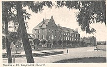
The Langemarck barracks is a military property in Koblenz that is named after the battlefield near Langemark on which German troops attacked on November 10, 1914, in the third phase of the First Battle of Flanders in World War I. Although the buildings in the Lützel district were not built as barracks and most of the time did not serve this purpose, the name introduced by the Wehrmacht has been retained. Today, parts of the BAAINBw and the military engineering study collection are housed on the site .
history
From 1907 the construction of the facility as a corps clothing office of the VIII Army Corps began on the site of the Moselflesche , which was abandoned on March 13, 1890 and largely laid down by 1903 . The complex was completed in 1910. The clothing office, which had among other things stored the uniforms and personal equipment for the reservists of this army corps to be called up in the event of mobilization , consisted of four large storage buildings, the guard house, the commandant's house, three administration buildings and a double row of sheds . In 1900/01, however, the garrison steam washing facility was built in the filled front ditch . As with the former fortress, the main entrance was in the east and was accessible from Mariahilfstrasse.
The barracks are now located on Mayener Straße (house numbers 83 A to at least 91), which runs along the north side of the property and which is a section of the federal highway 416 there . Until 1934, the entrance to the property was on Langemarckplatz to the east of the property, which Mayener Strasse crossed - at that time in an east-south-east direction. In the course of the four-lane expansion of Bundesstraße 9 , which crosses Mayener Straße on Langemarckplatz, the crossing on Langemarckplatz was designed to be free of height . The entrance to the barracks, however, had already been relocated to Mayener Strasse when the Moselle Bridge was being built. When Langemarckplatz was redesigned, the sidewalk was moved along the barracks area directly to the buildings, with the strip in front of it being included with the former barracks fence. The gaps between the structures were closed with parts of the barracks fence (lattice fence). The bus stop on Mayener Strasse, on the corner of Karl-Russell-Strasse, directly in front of the barracks property, is called "Langemarckplatz" (or "Lützel Langemarckpl.").
After the end of the First World War , the city of Koblenz took over the site, which was initially confiscated by the American and later by the French occupation, and the latter occupied it with troops as Caserne Valmy . Only after the French withdrew in 1929 was the city able to dispose of the property again.
After the remilitarization of the Rhineland in 1936, the Wehrmacht took over the barracks the following year and named it "Langemarck Barracks". After the renovation in 1937-38 it was first with the pioneer - Battalion 34 occupied, which was later replaced by the observation section 34 then a year. This unit (or its replacement unit) remained stationed here until the end of the Second World War .
After the war, which the buildings had survived badly damaged, the barracks were rebuilt in a simplified form and again occupied by French occupation troops. Since mainly Chasseurs à pied were stationed here, the area was now called Quartier Général Frère, and for some time a Moroccan infantry unit was also housed in the barracks.
The last units of the French army left in 1969 the 2 e bataillon de chasseurs à pied (2nd battalion hunters on foot) and the 40 e compagnie de transmissions (40th telecommunications company) in the direction of Neustadt, the barracks and thus Koblenz. The city's vehicle registration office was then housed in the north-western block and parts of the building were used by a freight forwarder. The Office for Fire and Disaster Protection also had a unit of the volunteer fire brigade stationed here and used it as an emergency warehouse. A motor vehicle repair shop was located in parts of the former coach houses in the courtyard.
In 1980 the Federal Office for Defense Technology and Procurement moved into the property, whereby the block last used for civilian purposes was handed over to the Defense Technology Study Collection (WTS). Due to the constant enlargement of the WTS it became necessary to demolish the front area of the remise and to build some large halls in its place where large equipment is exhibited.
For reasons of space, it was decided in 2004 to relocate the defense technology study collection to the technical area west of the former Fritsch barracks in Koblenz-Niederberg . For reasons of cost, however, this has not been implemented.
In the meantime it has been established that the WTS will leave the former barracks and move to the site of the branch (water place) of the Defense Technical Service 41 in Koblenz-Metternich . The project is in the planning phase (2017).
The Langemarck barracks are on the list of properties to be surrendered in the long term on the Bundeswehr intranet .
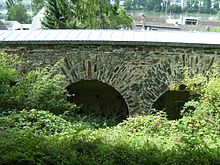
On the south-south-east side of the Mayener Straße building, house number 85 (one of the original warehouse buildings), which is used by the Defense Technical Study Collection at BAAINBw and has been connected to the large equipment hall, there is a fragment of a grave slab (made of basalt lava) with a bas-relief , which probably consists of the 1st half of the 16th century; the fragment of the grave slab is a cultural monument of the independent city of Koblenz. At the southern border of the property there are still remnants of the Moselflesche (the southern face with escarpment with circular corridor and transverse walls and, at an obtuse angle , the adjoining lining wall ), which are also listed as a cultural monument in the monument register.
See also
literature
- Rüdiger Wischemann: The Koblenz Fortress. From the Roman fort and Prussia's strongest fortress to the largest garrison of the Bundeswehr. Rhenania bookstore, Koblenz 1978.
- Sabine Bauer, Matthias Kellermann: The Moselflesche since 1900: laundromat, clothing office, Langemarck barracks. In: Feste Kaiser Franz. On the history of the fortress and the Feste Franz system in Koblenz-Lützel. Festschrift for the 10th anniversary of Feste Kaiser Franz eV, published by Feste Kaiser Franz eV 2nd edition. Fölbach, Koblenz 2009, ISBN 978-3-934795-55-6 , pp. 56-64.
- Your location in Koblenz-Lahnstein. Bundeswehr information leaflet, born in 1979.
Web links
Notes and evidence
- ↑ The municipality of Langemark-Poelkapelle writes its capital today uniformly without the "c" before the "k". The barracks only officially bore the name "Langemarck-Kaserne" from 1936–1945; Langemarckplatz in the Koblenz district of Lützel is still spelled with "ck", as is the bus stop named after it.
- ↑ In the administration building of the WTS there is still the guard room with a switch to the stairwell.
- ↑ In memory of the fighting near Langemarck (now Langemark) 1914–1918.
- ↑ The neo-baroque gables were left out.
- ↑ In the French army , the hunter barracks are called "Quartier" and not "Caserne".
- ↑ Informational directory of the cultural monuments of the district-free city of Koblenz. List of monuments, district-free city of Koblenz. Published by the General Directorate for Cultural Heritage Rhineland-Palatinate , November 25, 2015. Chapter: Koblenz - Lützel, p. 26, accessed and received on February 11, 2016 (PDF file; 6.53 MiB). Which building in Mayener Strasse bears house number 85 can be seen from the DTK 1: 5,000 in color in connection with the house number labeling from the ALKIS of the authorities of the surveying and cadastral administration (upper state authorities in the business area of the Ministry of the Interior, for sport and infrastructure Rhineland-Palatinate ) in the landscape information system of the Nature Conservation Administration (LANIS) (map server) of the Ministry for the Environment, Agriculture, Food, Viticulture and Forests Rhineland-Palatinate , accessed and received on February 11, 2016 (German, XHTML, zoom in on the map and click on the Center the building marked with the red cross, then the house number becomes legible). There is also a map of the cultural monuments in the district-free city of Koblenz in GeoPortal.rlp . Editor of GeoPortals.rlp : Steering Committee for Geodata Infrastructure RP (GDI-RP) in the Ministry of the Interior, for Sport and Infrastructure of the State of Rhineland-Palatinate . Responsible for the content of the GeoPortal .rlp: Central Office Geodata Infrastructure Rhineland-Palatinate in the State Office for Surveying and Basic Geographic Information Rhineland-Palatinate . Accessed and received on February 11, 2016 (German, XHTML). (By entering the address “Mayener Straße 85, 56070 Koblenz” in the search bar on the map, the map can be centered on the building with the corresponding house number; this building is marked with the small pale red dot with a red border in the middle of the map Areas with a black border mark cultural monuments, the fragment of the grave slab on the building with house number 85 is marked by a circular such area.)


