Lützelburg (Kempten)
The Lützelburg ( Middle High German lützel , lützelig 'small', 'little'; meaning small castle ) is a castle stable and thus also a ground monument in Kempten (Allgäu) . Exact dates of creation and ownership are not known. Johann Baptist Haggenmüller , in his 1840 history book, History of the City and the Princes of Kempten, refers to a wooden bridge between the Burghalde ("Hilarmont") located just a few meters further north and the Lützelburg in the 11th century. Correct evidence for this is not known. According to Joseph Meirhofer (1854), the castles were connected by a "corridor".
In one of the oldest general views of the city, a woodcut by Hanß Abelin and Hanß Rogel from 1569, there is still a castle on the hill. In a picture from 1673 that Matthäus Merian drew, the Lützelburg is shown as a ruin.
In 1920 an allotment garden was laid out to the east below the hill (Lützelburg garden) . During the Second World War there was a protective bunker in the hill.
The memorial stone , erected in 1939 and initiated by Otto Merkt , reminds of the lost castle with the following inscription, the content of which is not documented:
Lützelburg or Small Castle
around the year 1000 BC Chr.
Separated
by nature from the Iller around 440 destroyed by the Huns rebuilt
in 1063 by Duke Rudolf
von Bayern abbot of Kempten
castle inhabited 1359 - destroyed in the Swedish
war
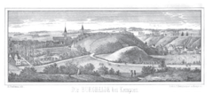
The Burghalde in the right half of the picture behind the smaller Lützelburg, anonymous woodcut from 1567, seen from the south
Individual evidence
- ^ Johann Baptist Haggenmüller: History of the city and the princes of Kempten. 1840, pp. 69–70 ( online ): … so in 1063 Duke Rudolf received the Kempten Abbey as a gift… The Duke had Hilarmont Castle put in a defensive position, Lützelburg Castle built on the hill below it to the south, and both castles connect by a wooden bridge.
- ↑ Joseph Meirhofer: Die Burghalde bei Kempten , Kempten 1854, p. 11 ( online )
- ↑ Otto Merkt: Castles, entrenchments and gallows in the Allgäu: the small Allgäu castle book . Kösel-Verlag, Kempten (Allgäu) 1951, p. 114.
Web links
Coordinates: 47 ° 43 ′ 18.3 " N , 10 ° 19 ′ 13.7" E


