Lake George (New South Wales)
| Lake George (Werriwa) | ||
|---|---|---|

|
||
| Lake George in August 2005 | ||
| Geographical location | 29 km northeast of Canberra | |
| Tributaries | Taylors Creek, Butmaroo Creek, Turalla Creek | |
| Drain | evaporation | |
| Data | ||
| Coordinates | 35 ° 6 ′ S , 149 ° 25 ′ E | |
|
|
||
| Altitude above sea level | 661 m | |
| surface | 150 km² | |
| length | 25 km | |
| width | 10 km | |
| volume | 0.15 km³ | |
| Maximum depth | 2 m | |
| Middle deep | 1 m | |

|
||
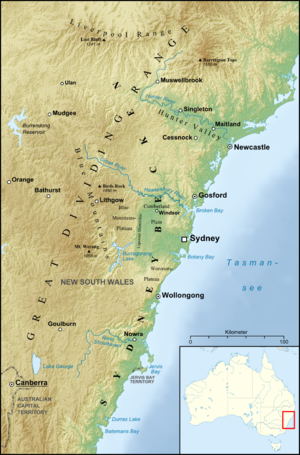
| Map of the Sydney Basin , with Large George to the south | ||
Lake George is a lake in the southeastern part of New South Wales , northwest of the LGA Palerang Council and 29 kilometers northeast of Canberra in Australia . The lake lies at an altitude of 661 meters. The lake, which is usually around 15,000 hectares in size, is relatively shallow, which is why the area regularly fluctuates strongly depending on the season. Currents and eddies have caused fatal accidents several times.
As one of only two freshwater lakes in the higher regions of New South Wales, it is an important roost for birds in dry seasons. It serves as a habitat for 201 bird , 31 mammal , 29 reptile and 12 amphibian species .
Also known is a mirage ( mirage ) that makes the lake appear full when it is empty. Since 1820 it has dried out completely a few times, but mostly it contained water. It was founded by British settlers after the British King George III. named, but was called Werriwa in the language of the locals .
