Lake Matheson
| Lake Matheson | ||
|---|---|---|

|
||
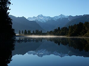
| Lake Matheson with reflection of Mt. Tasman (left) and Mt. Cook | ||
| Geographical location | South Island New Zealand | |
| Drain | Clearwater River | |
| Data | ||
| Coordinates | 43 ° 26 '22 " S , 169 ° 57' 54" E | |
|
|
||
| length | 600 m | |
| width | 200 m | |
The Lake Matheson is a small lake near the west coast of the South Island of New Zealand . It is famous for the fact that Aoraki / Mount Cook and Mount Tasman are reflected on the surface of the water when viewed from the northwest .
geography
The lake is part of the Westland Tai-Poutini National Park and is located a few kilometers northwest of the Fox Glacier . The lake is only 600 m long and 200 m wide. The lake is drained via the Clearwater River into the Fox River and further into the Tasman Sea. The lake is less than ten kilometers from the coast.
Emergence
Lake Matheson was formed about 14,000 years ago after the Fox Glacier's last advance. The retreat of the glacier left a depression that filled with water.
Others
The water of the lake is colored brown by the entry of organic materials from the surrounding forest area. Due to its elongated basic shape and the wooded banks, the water is often mirror-smooth, so that the reflections of the mountains to the south-east can be seen in the morning and evening hours. A hiking trail leads from the nearby parking lot around the lake.

