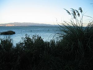
Lake Wairarapa
| Lake Wairarapa | ||
|---|---|---|

|
||
| View from the west towards the Aorangi Range | ||
| Geographical location | South Wairarapa District , Wellington , New Zealand | |
| Tributaries | Ruamahanga River | |
| Drain | Ruamahanga River | |
| Location close to the shore | Masterton , Lower Hutt , Featherston | |
| Data | ||
| Coordinates | 41 ° 12 '47 " S , 175 ° 14' 32" O | |
|
|
||
| surface | 78 km² | |
| Maximum depth | 2.5 m | |
|
particularities |
third largest lake on the North Island (after Lake Taupo and Lake Rotorua ) |
|
Lake Wairarapa is a lake in the south of the North Island of New Zealand in the Wairarapa area of the same name .
It is located in the South Wairarapa District within the Wellington region about 50 kilometers east of Wellington . With an area of 78 km², it is the third largest lake on the North Island. The closest town is Featherston and is about 3 miles north.
The lake is fed by several rivers. The most important inflow was the Ruamahanga River which is also the most important outflow. However, it was diverted around the lake and now flows east of the lake. Only about 10 kilometers south of the lake, the river flows into the Cook Strait at Palliser Bay . The catchment area is large and also includes parts of the Remutaka Range and the Tararua Range .
The area around the lake is swampy and forms a natural space that includes rare water birds and fish. The Māori have used this area for a long time to find food easily.
Web links
- Wairarapa's natural treasure . Wairarapa Times Age, archived from the original onOctober 7, 2008; accessed on August 26, 2014(English, original website no longer available).
