Lamentation Mountain State Park
|
Lamentation Mountain State Park
|
||
|
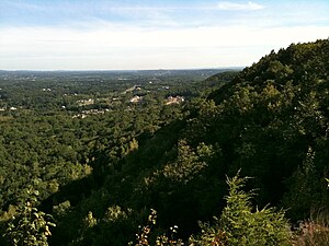
View from the apex of the Mattabesett ridge line in Guiffrida Park north on Lamentation Mountain. |
||
| location | Hartford County (USA) | |
| surface | 0.19 km 2 | |
| Geographical location | 41 ° 35 ' N , 72 ° 46' W | |
|
|
||
| Setup date | 1919 | |
| administration | Dept. of Energy & Environmental Protection, State of Connecticut | |
Lamentation Mountain State Park is a small state park in Hartford County in the New England town of Berlin , Connecticut . The park is undeveloped. It offers opportunities for hiking. The park is on the west flank of Lamentation Mountain near the Mattabesett Trail . It is bounded to the west by the Wilbur Cross Highway (State road No. 5) and overlooks Silver Lake . To the east it borders the Doctor Francis Giuffrida Park . The Lamentation Mountain is a basalt -Klippe that during the Triassic , the divergence has formed from Europe and America.
See also
Individual evidence
- ↑ http://www.ct.gov/deep/cwp/view.asp?a=2716&q=445284&#LamentationMountain Lamentation Mountain State Park
Web links
- Lamentation Mountain State Park Connecticut Department of Energy and Environmental Protection
- Lamentation Mountain State Park on the United States Geological Survey's Geographic Names Information System

