
Long alders

The long alders are a Swiss plain with riparian forest along the Wiese River and extend over the city limits from Basel to Riehen on the German-Swiss border. This important local recreation area takes its name from the time before the meadow was canalized. Alders are typical riparian trees. This area still includes 180 hectares of forest. Targeted forest management has made it possible to replace almost all of the old trees. The name of the Eglisee garden pool is also reminiscent of the former meadow landscape, even if it is derived from a standing body of water originally called Egelsee .
The long alder trees are used intensively by walkers, joggers, walkers, inline skaters and cyclists. In addition, there is the Lange Erlen zoo , which is used for agriculture and forestry . There are also family gardens and sports facilities. The Lange Erlen area is part of the Wiese Landscape Park , which stretches between Weil am Rhein, Riehen and Basel and is identified as such by information boards.
However, the most important use is the pumping of groundwater to feed Basel's drinking water supply . About fifty percent of the city's drinking water is produced in the meadow plain. In order to prevent an excessive lowering of the groundwater, Rhine water is seeped into wooded water points . The Rhine water, around 60,000 m³ per day, is freed of its suspended matter by means of complex sand filtration and then distributed to eleven water points totaling around 13 hectares . The water is cleaned in the floor passage and can then be pumped from several wells as safe drinking water. The Riehenteich power plant supplies some of the energy required for this . Its turbines are driven by the channel of the same name, which is derived from the meadow in the long alders.
Until the late Middle Ages , the meadow did not have a uniform river bed, but flowed in alternating courses towards the Rhine. Over the past 200 years, the meadow has been completely built and straightened with the aim of reclaiming land and protecting against flooding. Today the river flows through the plain as a straight channel, is equipped with numerous thresholds and allows little contact with its former meadow landscape . But now the barriers are starting to be torn up again and the meadow is being revitalized. It is hoped that this will increase the biodiversity of plants and animals and make them more attractive to humans and water dwellers.

Meadow upstream
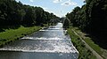
Meadow downstream - view towards the confluence with the Rhine
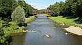
Meadow upstream - old railway bridge


literature
- Rolf Wehrlin: The long alders . In: Jahrbuch z'Rieche 1963 ( online ).