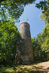
Kikut lighthouse
| Kikut lighthouse | ||
|---|---|---|
| Place: |
|
|
| Location: | Forst Warnow in Wolin National Park | |
| Geographical location: | 53 ° 58 '53.2 " N , 14 ° 34' 49.1" E | |
| Fire carrier height : | 18.2 m | |
| Fire height : | 91.5 m | |
|
|
||
| Identifier : | Iso.W.10s | |
| Construction time: | 1826 as a beacon | |
| Operating time: | since 1962 | |
| International ordinal number: | C 2892 | |
The lighthouse Kikut (Eng. Lookout ) is a lighthouse on the Baltic Sea , north of the Polish holiday and seaside resort of Wisełka , 300 m from the shoreline. Its height is 18.20 m.
history
In 1826, a beacon in the form of a Dutch windmill without wings was built on the Swiner Hoft or Kiesberg (also: Kiekberg ) elevation between Swinhöft (Święta Kępa) and Neuendorf . It burned down on the night of August 6th, 1839. It was rebuilt in 1840.
In the annual reports on the activities of the Deutsche Seewarte in the period from 1925 to 1935, Fr. Brandenburg is named as the signal keeper at the storm warning station there .
The tower that still exists today ( Strażnica = watchtower) is the result of a reconstruction of the old beacon with hewn field stones in 1961. On January 15, 1962, the conversion of the tower into a fully automatic lighthouse (Latarnia Morska Kikut) was officially completed. Since then he has been wearing a lantern with a cylinder or belt lens that is darkened on the land side. The renovation was necessary to secure the coast between the neighboring lighthouses. The nautical chart with numerous recorded wrecks speaks for itself. The Kikut is 91.5 m above sea level, making it the highest beacon in Poland. The light can be seen around 16 nautical miles across the Baltic Sea.
The lighthouse is operated by the Seeamt in Szczecin and is not open to the public. It is fully automated and serves as one of the eleven coastal stations on the Polish coast of the AIS-PL system , HELCOM project , which enables automatic monitoring of shipping traffic in the coastal zone. The antenna station is 95 m high.
The built-in lantern device consists of a cylindrical 500 mm lens and a changer with 6 bulbs of 75 watts each in the event of a failure.
Not far from the location of the Kikut , from the “Stinas Utkiek”, the Pomeranian pirate Stina, leader of a group of woolen pirates and companion of Klaus Störtebeker , is said to have looked out for the pirates . If a red flag was waving on the bank, Störtebeker is said to have known that there was no threat.
literature
- Gerd Liedtke: "50 years of the Kikut lighthouse (Wiselka)". In: Leuchtfeuer , Volume 20 (Autumn / Winter 2012), No. 63, pp. 15-17.
- Martin Zamorski and Wolfgang Abraham: Wollin Island and surroundings - hiking and cycling. Rajd Verlag, Warsaw 2010, ISBN 978-83-60838-15-0 .
- Małgorzata Rajchowiak: "Kikut Lighthouse". In: Latarnie morskie - Wybrzeża Zachodniego . Arguss, Szczecin 1997, ISBN 83-907024-0-1 (German).
Web links
- baken-net.de
- Study on the Polish lighthouses , latarnie.com.pl (German)
- Lighthouses in West Pomerania , meerderablebnis.eu
- Photos from inside the light house , Leuchtturm-web.de
- Latarnia Morska Kikut: Detailed information on automation 1962 , Leuchtturm-anke.de
- Significance and availability based on expert advice , blinkfuuer.de
Footnotes
- ↑ Sundine: entertainment sheet for New Western Pomerania and Rügen , Beiblatt, Stralsund, September 4, 1839 (p. 143).
- ↑ Official Journal No. 5 and 6, Szczecin, February 5, 1841.
- ↑ Exemplary: Annual report on the activities of the Deutsche Seewarte, 1928, p. 9.
- ↑ Tourist Map - Wollin Island and Surroundings, Warsaw 2012.
- ↑ Marek Dziewicki, Marcin Waraksa: Status AIS - PL. Urząd Morski w Gdyni , 2007.
- ↑ WZ No. 6/61. Gdynia 1962 (NfS. No. 766 of February 24, 1962).
- ↑ German sagas. Selected by Ernst Jaedicke, Deutsche Buchgemeinschaft, Berlin 1925, projekt.gutenberg.de.

