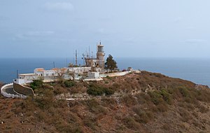
Dakar lighthouse
| Dakar lighthouse | ||
|---|---|---|
| Phare des Mamelles | ||
| Place: |
|
|
| Location: | highest point on the peninsula at Ouakam | |
| Geographical location: | 14 ° 43 '25.7 " N , 17 ° 30' 6.4" W | |
| Height of tower base: | 105 m | |
| Fire carrier height : | 16 m | |
| Fire height : | 120 m | |
|
|
||
| Identifier : | Fl.5s120m31M | |
| Scope knows: | 31 nm (57.4 km ) | |
| Optics: | Fresnel lens | |
| Operating mode: | 1000 watt lamp | |
| Construction time: | 1864 | |
| Operating time: | since 1864 | |
| International ordinal number: | D 3004 | |
The lighthouse of Dakar ( French Phare des Mamelles ) is located on the Cap-Vert peninsula about nine kilometers from the city center of Dakar in the Ouakam district and marks the westernmost point of the African continent. The location chosen was the summit of the highest elevation on Cap Vert, the western one of two closely spaced hills of volcanic origin. These are known as " Les Mamelles " ( German : breasts ) because of their conical shape .
history
The lighthouse , built in 1864, is the oldest in Dakar. In 1911 a renovation took place.
Technical specifications
The identification of the beacon is Fl.5s120m31M, so it flashes white every 5 seconds, the height of the fire is 120 meters above sea level and the nominal range is calculated at 31 nautical miles . The tower has a height of 16 meters and stands on the 105 meter high hill. Its beacon is next to the Cape Point Lighthouse near Cape Town as the strongest in Africa; it has a range of around 57 kilometers. The light from a 1000 watt lamp is amplified via a Fresnel lens .
tourism
The lighthouse can be visited freely. From the tower, but also from the hill, the visitor has a view of the peninsula, the Îles de la Madeleine and the city itself.
Individual evidence
- ↑ OpenSeaMap

