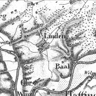
Linnebecke
|
Linnebecke Right tributary near Dahlhausen |
||
|
Linden, 1800. North of the town center, the Linnebecke. |
||
| Data | ||
| Water code | DE : 276954 | |
| location | Bochum , North Rhine-Westphalia , Germany | |
| River system | Rhine | |
| Drain over | Ruhr → Rhine → North Sea | |
| origin | south of Weitmar house 51 ° 26 ′ 47 ″ N , 7 ° 11 ′ 23 ″ E |
|
| muzzle | in Dahlhausen in the Ruhr Coordinates: 51 ° 25 ′ 31 ″ N , 7 ° 8 ′ 22 ″ E 51 ° 25 ′ 31 ″ N , 7 ° 8 ′ 22 ″ E
|
|
| length | 4.3 km | |
The Linnebecke is a flowing body of water in the area of the Weitmar , Linden and Dahlhausen districts of Bochum . The brook rises southwest of the Weitmar house and used to feed its graves , drains to the southwest and flows into the Ruhr near Dahlhausen . A section of the Hasenwinkel coal route , the Dahlhaus horse railway, ran in its valley . The stream flows along the streets Am Röderschacht , An der Steinhalde and Am Sattelgut . It is largely piped.
