List of architectural monuments in Beverstedt
In the list of architectural monuments in Beverstedt , all listed buildings of the Lower Saxon community Beverstedt (district of Cuxhaven) are summarized. The basis is the publication of the district's list of monuments. The numbering here refers to the consecutive numbering of the official list.
Appeln - Abelhorst district
| Code number Meaning of |
location | designation | size in m² |
description | image |
|---|---|---|---|---|---|
| 35.200.100.001 GWS |
Abelhorster Straße 19, 27616 Beverstedt (Appeln-Abelhorst) location |
Sheepfold | 70.775 |
|
Beverstedt
Beverstedt (core town)
| Code number Meaning of |
location | designation | size in m² |
description | image |
|---|---|---|---|---|---|
| 35.200.500.016 G |
Wesermünder Strasse, 27616 Beverstedt location |
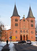
church | 726.818 | The Evangelical Church of Fabian-und-Sebastian was built from 1849 to 1851. The church has a twin tower that characterizes the townscape. Inside there is a baptism from the 13th century, and an altar from the mid-15th century. |

|
| 35.200.500.017 G |
Wesermünder Strasse, 27616 Beverstedt location |
cenotaph | 4,000 | (1914/18) |
|
| 35.200.500.018 G |
Wesermünder Strasse, 27616 Beverstedt location |
cenotaph | 4,000 | (1870/71) |
|
| 35.200.500.019 GWS |
Hindenburgstraße 24, 27616 Beverstedt location |
Residential / farm buildings | 296.267 |
|
|
| 35.200.500.059 G |
Mühlenstrasse / Marienburger Strasse, 27616 Beverstedt location |
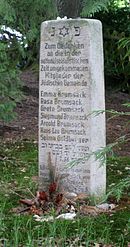
graveyard | 297.223 | The Jewish cemetery was occupied from 1805 to 2011. There are 21 tombstones on it. |

|
| 35.200.500.060 G |
Mühlenstrasse, 27616 Beverstedt |
Course of the road | 3,194.093 | Mühlenstrasse |
|
Beverstedt - Deelbrügge district
| Code number Meaning of |
location | designation | size in m² |
description | image |
|---|---|---|---|---|---|
| 35.200.500.015 G |
Deelbrügge, 27616 Beverstedt (Deelbrügge) location |
Watermill | 136.252 | Deelbrugge watermill |

|
Beverstedt - Easter village district
| Code number Meaning of |
location | designation | size in m² |
description | image |
|---|---|---|---|---|---|
| 35.200.500.012
G single monument |
Wollingster Strasse 2, 27616 Beverstedt (Easter village) location |
manor | 340.795 |

|
|
| 35.200.500.021 G |
Körnerstraße 2 A, 27616 Beverstedt (Easter village) location |
Residential building | 340.038 | Mansion |
|
Beverstedt - Wachholz district
| Code number Meaning of |
location | designation | size in m² |
description | image |
|---|---|---|---|---|---|
| 35.200.500.010 G |
Wachholz 4, 27616 Beverstedt (Wachholz) location |
Residential / farm buildings | 322.169 | Good wax |

|
Beverstedt - district of Wellen
| Code number Meaning of |
location | designation | size in m² |
description | image |
|---|---|---|---|---|---|
| 35.200.500.002 G |
Kramelheide 7, 27616 Beverstedt (Wellen) |
Residential / farm buildings | 225.827 |
|
|
| 35.200.500.004 G |
Waldstraße 19, 27616 Beverstedt (Wellen) location |
Residential / farm buildings | 313,331 |
|
|
| 35.200.500.006 GKW |
Nasse Strasse 14, 27616 Beverstedt (Wellen) location |
manor | 411.631 |

|
|
| 35.200.500.007 GWS |
Hellingster Weg 6, 27616 Beverstedt (Wellen) location |
Residential / farm buildings | 306.738 | The building was constructed in 1704. A dendrochronological examination of the beams of the inner framework revealed a precipitation date of 1522. |
|
| 35.200.500.007 GWS |
Hellingster Weg 6, 27616 Beverstedt (Wellen) location |
enclosure | 187,359 | Field stone wall |
|
| 35.200.500.008 GWS |
Hellingster Weg 6, 27616 Beverstedt (Wellen) location |
barn | 23.657 | The stable was probably built around 1750. |
|
| 35.200.500.009 G |
Aher Weg 20, 27616 Beverstedt (Wellen) location |
Residential / farm buildings | 195.857 | The residential building is a two-tier house, it was probably built in the second half of the 17th century. |
|
Bokel
| Code number Meaning of |
location | designation | size in m² |
description | image |
|---|---|---|---|---|---|
| 35.200.600.001 GWS |
Auf dem Brink 7, 27616 Beverstedt (Bokel) Lage |
Residential / farm buildings | 161.085 |
|
|
| 35.200.600.002 GWS |
Auf dem Brink 7, 27616 Beverstedt (Bokel) |
barn | 56.45 |
|
|
| 35.200.600.004 G |
Hauptstraße 74, 27616 Beverstedt (Bokel) location |
Residential / farm buildings | 289.174 |
|
|
| 35.200.600.006 S |
Loher Strasse, 27616 Beverstedt (Bokel) location |
Course of the road | 10,949.153 | Lohkamp |
|
Frelsdorf
| Code number Meaning of |
location | designation | size in m² |
description | image |
|---|---|---|---|---|---|
| 35.201.700.001 G |
Frelsdorfermühlen, 27616 Beverstedt (Frelsdorf) location |
mausoleum | 18,181 | The tomb was built in 1791. It is a brick building with a gable roof. |
|
| 35.201.700.002 G |
Frelsdorfermühlen 4, 27616 Beverstedt (Frelsdorf) location |
villa | 323.23 | The estate was founded in 1583. The manor house was rebuilt by Baroness Mia con Hodenberg from 1894. It is a brick building with two storeys and some roof houses. The mansion is in a park. |
|
| 35.201.700.003 G |
Frelsdorfermühlen 3, 27616 Beverstedt (Frelsdorf) location |
Gatehouse | 187.749 | The wall stud construction is now used as a residential building. The house was built in 1624. |
|
| 35.201.700.004 G |
Schmiedestraße 2, 27616 Beverstedt (Frelsdorf) location |
Fence barn | 73.79 |
|
|
| 35.201.700.005 GKWS |
Raiffeisenstraße 2 B, 27616 Beverstedt (Frelsdorf) location |
Residential / farm buildings | 226.138 | Half-timbered house |
|
| 35.201.700.006 G |
Malser Straße 7, 27616 Beverstedt (Frelsdorf) location |
Residential / farm buildings | 64.619 |
|
|
| 35.201.700.007 GS |
In der Hörne 1, 27616 Beverstedt (Frelsdorf) Lage |
Residential / farm buildings | 284.867 |
|
|
| 35.201.700.008 S |
In der Hörne 1, 27616 Beverstedt (Frelsdorf) Lage |
barn | 109.751 |
|
|
| 35.201.700.011 G |
Geestenether Straße 12, 27616 Beverstedt (Frelsdorf) location |
Residential / farm buildings | 335,326 |
|
|
| 35.201.700.013 GS |
Raiffeisenstraße 2, 27616 Beverstedt (Frelsdorf) location |
Residential / farm buildings | 358.397 | Brick construction (1905) |
|
| 35.201.700.014 - |
Auf dem Brink 3, 27616 Beverstedt (Frelsdorf) location |
Fachhallenhaus | 242.497 |

|
Heerstedt
Hollen
Hollen (core town)
| Code number Meaning of |
location | designation | size in m² |
description | image |
|---|---|---|---|---|---|
| 35.202.300.001 GWS |
At the farmers 1, 27616 Beverstedt (Hollen) |
Cross barn | 250.22 |

|
Hollen - district of Heise
Kirchwistedt
Kirchwistedt (core town)
| Code number Meaning of |
location | designation | size in m² |
description | image |
|---|---|---|---|---|---|
| 35.202.600.005 GWS |
Raiffeisenstrasse 2, 27616 Beverstedt (Kirchwistedt) |
Residential / farm buildings | 342,803 |
|
|
| 35.202.600.006 GKS |
Hauptstraße 7, 27616 Beverstedt (Kirchwistedt) location |
church | 249,417 | The Protestant church of St. John the Baptist dates back to the 13th century. The tower was built in 1894/1895. Inside an organ from 1863 and a baptism from 1402. |
|
| 35.202.600.007 G |
Hauptstraße 7, 27616 Beverstedt (Kirchwistedt) location |
Churchyard | 1,339.876 |
|
|
| 35.202.600.008 G |
Hauptstraße 7, 27616 Beverstedt (Kirchwistedt) location |
Field stone wall | 152.525 |
|
Kirchwistedt - Ahe district
| Code number Meaning of |
location | designation | size in m² |
description | image |
|---|---|---|---|---|---|
| 35.202.600.002 GWS |
Ahe 9, 27616 Beverstedt (Kirchwistedt-Ahe) |
Cross barn | 212.797 |
|
|
| 35.202.600.003 GWS |
Ahe 9, 27616 Beverstedt (Kirchwistedt-Ahe) |
Bakehouse | 26,846 |
|
|
| 35.202.600.004 WS |
Ahe 8, 27616 Beverstedt (Kirchwistedt-Ahe) location |
avenue | 87.018 | Property boundary with fencing |
|
| 35.202.600.011 WS |
Ahe 7–9, 27616 Beverstedt (Kirchwistedt-Ahe) location |
avenue | 86,364 | Property boundary with fencing |
|
Kirchwistedt - Altwistedt district
Kirchwistedt - Stemmermühlen district
Lunestedt
Lunestedt - Freschluneberg district
| Code number Meaning of |
location | designation | size in m² |
description | image |
|---|---|---|---|---|---|
| 35.203.200.006 GWS |
Freschluneberger Strasse, 27616 Beverstedt (Lunestedt-Freschluneberg) |
Cross barn | 91.544 |

|
|
| 35.203.300.007 GS |
Freschluneberger Strasse 26, 27616 Beverstedt (Lunestedt-Freschluneberg) |
Residential / farm buildings | 187.168 |

|
|
| 35.203.300.008 GWS |
Freschluneberger Strasse 26, 27616 Beverstedt (Lunestedt-Freschluneberg) |
barn | 54.823 |
|
|
| 35.203.300.009 GWS |
Freschluneberger Straße 26 A, 27616 Beverstedt (Lunestedt-Freschluneberg) |
Cross barn | 73.382 |
|
|
| 35.203.300.010 GKW |
Kirchenstraße 27, 27616 Beverstedt (Lunestedt-Freschluneberg) location |
Residential building | 376,085 | The residential building of a courtyard was built in 1895. It's a single story house. |

|
Lunestedt - Westerbeverstedt district
Former architectural monument
Stubben - Elfershude district
| Code number Meaning of |
location | designation | size in m² |
description | image |
|---|---|---|---|---|---|
| 35.205.300.001 GS |
Martin-Börsmann-Straße 1, 27616 Beverstedt (Stubben-Elfershude) location |
Residential / economic building | 169.291 |
|
Abbreviations in the column code number / meaning
Abbreviation:
- G = historical meaning
- K = artistic meaning
- W = scientific importance
- S = urban development significance
literature
- Doris Böker (arrangement): Monument topography Federal Republic of Germany, architectural monuments in Lower Saxony . Ed .: Christiane Segers-Glocke (= publications of the Institute for Monument Preservation - Lower Saxony State Administration Office - District of Cuxhaven . Volume 19 ). CW Niemeyer Buchverlage , Hameln 1997, ISBN 3-8271-8259-X .
Web links
- Architectural monuments in the municipality of Beverstedt in the Cuxland GIS


