|
Serial No.
|
Name in the NRHP
|
image
|
Year of registration
|
Address / location
|
place
|
NRHP ID
|
|
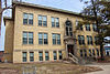
1
|
Agriculture and Manual Arts Building / Platteville State Normal School
|
|
1985
|
University of Wisconsin, Platteville
42 ° 44 ′ 3 " N , 90 ° 29 ′ 10" W.42.734166666667 -90.486111111111
|
Platteville
|
85000578
|
|
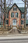
2
|
LJ Arthur House
|

|
1985
|
210 North Jefferson Street
42 ° 50 ′ 57 " N , 90 ° 42 ′ 39" W.42.849166666667 -90.710833333333
|
Lancaster
|
85001951
|
|
3
|
James Ballantine House
|

|
1976
|
720 North 4th Street
42 ° 53 ′ 16 ″ N , 90 ° 55 ′ 34 ″ W.42.887777777778 -90.926111111111
|
Bloomington
|
76000062
|
|
4th
|
Bass Site (47Gt25)
|
|
1982
|
|
Lancaster
|
82000669
|
|
5
|
Bayley Avenue Historic District
|

|
2007
|
100-400 Bayley Avenue, 400 Block South Court Street, 150, 210, 270 Rountree Avenue, and 65 Mitchell Avenue
42 ° 43 ′ 52 ″ N , 90 ° 28 ′ 46 ″ W.42.731111111111 -90.479444444444
|
Platteville
|
07000708
|
|
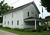
6th
|
Beebe House
|
|
1979
|
390 West Adams Street
42 ° 44 ′ 19 ″ N , 90 ° 28 ′ 49 ″ W.42.738611111111 -90.480277777778
|
Platteville
|
79000078
|
|
7th
|
Bode-Wad-Mi Rockshelter
|
|
1995
|
|
Castle Rock
|
95000760
|
|
8th
|
Boscobel Grand Army of the Republic Hall
|
|
2007
|
102 Mary Street
43 ° 7 ′ 55 " N , 90 ° 42 ′ 23" W.43.131944444444 -90.706388888889
|
Boscobel
|
07001329
|
|
9
|
Boscobel High School
|

|
1986
|
207 Buchanan Street
43 ° 7 ′ 59 " N , 90 ° 42 ′ 11" W.43.133055555556 -90.703055555556
|
Boscobel
|
86003518
|
|
10
|
Central House Hotel
|

|
1996
|
1005 Wisconsin Avenue
43 ° 8 ′ 4 " N , 90 ° 42 ′ 20" W.43.134444444444 -90.705555555556
|
Boscobel
|
96001361
|
|
11
|
Courthouse Square Historic District
|

|
2006
|
Bounded by Cherry Street, Jefferson Street, Madison Street, and Maple Street
42 ° 50 ′ 51 ″ N , 90 ° 42 ′ 36 ″ W42.8475 -90.71
|
Lancaster
|
06000233
|
|
12
|
Denniston House
|

|
1975
|
117 East Front Street
42 ° 42 ′ 45 ″ N , 90 ° 59 ′ 25 ″ W.42.7125 -90.990277777778
|
Cassville
|
75000213
|
|
13
|
Division Street Historic District
|

|
2007
|
200-300 Block Division Street, 145, 170, 175, 190, 195 and 220 South Chestnut Street
42 ° 43 ′ 57 ″ N , 90 ° 28 ′ 54 ″ W.42.7325 -90.481666666667
|
Platteville
|
07000709
|
|
14th
|
Eagle Valley Mound District
|
|
2001
|
|
Glen Haven
|
01000736
|
|
15th
|
Fred Edwards Site
|
|
1982
|
|
Burton
|
82005118
|
|
16
|
Jonathan H. Evans House
|

|
1982
|
440 West Adams Street
42 ° 44 ′ 20 ″ N , 90 ° 28 ′ 53 ″ W.42.738888888889 -90.481388888889
|
Platteville
|
82000670
|
|
17th
|
First Congregational Church
|

|
1985
|
80 Market Street
42 ° 44 ′ 9 ″ N , 90 ° 28 ′ 42 ″ W.42.735833333333 -90.478333333333
|
Platteville
|
85001359
|
|
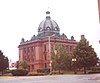
18th
|
Grant County Courthouse
|
|
1978
|
126 West Main Street
42 ° 50 ′ 51 ″ N , 90 ° 42 ′ 36 ″ W.42.8475 -90.71
|
Lancaster
|
78000096
|
|
19th
|
Hazel Green Town Hall
|

|
1989
|
2130 North Main Street
42 ° 32 ′ 0 ″ N , 90 ° 26 ′ 5 ″ W.42.533333333333 -90.434722222222
|
Hazel Green
|
88003231
|
|
20th
|
Hog Hollow Site
|
|
1996
|
|
Potosi
|
96000496
|
|
21st
|
Patrick and Margaret Kinney House
|

|
2008
|
424 North Fillmore Street
42 ° 51 ′ 6 ″ N , 90 ° 43 ′ 10 ″ W.42.851666666667 -90.719444444444
|
Lancaster
|
08000160
|
|
22nd
|
Lancaster Municipal Building
|

|
1983
|
206 South Madison Street
42 ° 50 ′ 51 " N , 90 ° 42 ′ 33" W.42.8475 -90.709166666667
|
Lancaster
|
83003397
|
|
23
|
Lancaster Post Office
|

|
2000
|
236 West Maple Street
42 ° 50 ′ 52 ″ N , 90 ° 42 ′ 43 ″ W.42.847777777778 -90.711944444444
|
Lancaster
|
00001245
|
|
24
|
Main Street Commercial Historic District
|

|
1990
|
Bounded by Chestnut Street, Furnace Street, Bonson Street, Mineral Street, Oak Street, and Pine Street
42 ° 44 ′ 4 ″ N , 90 ° 28 ′ 42 ″ W42.734444444444 -90.478333333333
|
Platteville
|
90000377
|
|
25th
|
Mitchell-Rountree House
|
|
1972
|
Jewett Street and Lancaster Street
42 ° 44 ′ 29 ″ N , 90 ° 28 ′ 57 ″ W.42.741388888889 -90.4825
|
Platteville
|
72000052
|
|
26th
|
Dwight T. Parker Public Library
|
|
1983
|
925 Lincoln Avenue
42 ° 59 ′ 0 ″ N , 90 ° 39 ′ 18 ″ W.42.983333333333 -90.655
|
Fennimore
|
83003398
|
|
27
|
Potosi Badger Huts Site
|
|
1996
|
8 km southwest of the junction of WI 133 with WI U
42 ° 41 ′ 10 ″ N , 90 ° 42 ′ 45 ″ W42.686111111111 -90.7125
|
Potosi
|
96001532
|
|
28
|
Potosi Brewery
|
|
1980
|
Main Street
42 ° 40 ′ 37 ″ N , 90 ° 43 ′ 32 ″ W.42.676944444444 -90.725555555556
|
Potosi
|
80000138
|
|
29
|
Rountree Hall
|

|
1974
|
30 North Elm Street
42 ° 44 ′ 7 " N , 90 ° 28 ′ 53" W.42.735277777778 -90.481388888889
|
Platteville
|
74000091
|
|
30th
|
JH Rountree Mansion
|
|
1986
|
150 Rountree Avenue
42 ° 43 ′ 56 " N , 90 ° 28 ′ 41" W.42.732222222222 -90.478055555556
|
Platteville
|
86001307
|
|
31
|
St. John Mine
|
|
1979
|
WI 133
42 ° 41 ′ 10 ″ N , 90 ° 42 ′ 56 ″ W.42.686111111111 -90.715555555556
|
Potosi
|
79000079
|
|
32
|
Stonefield
|

|
1970
|
4 km northwest of Cassville on County Road VV
42 ° 44 ′ 3 ″ N , 91 ° 1 ′ 18 ″ W42.734166666667 -91.021666666667
|
Cassville
|
70000034
|
|
33
|
West Main Street Historic District
|

|
2007
|
Bounded by Nort Elm Street, South Elm Street, West Pine Street, North Hickory Street, South Hickory Street, and West Mineral Street
42 ° 44 ′ 3 ″ N , 90 ° 28 ′ 43 ″ W42.734166666667 -90.478611111111
|
Platteville
|
07000710
|
|
34
|
Wyalusing State Park Mounds Archeological District
|
|
1999
|
13342 County Highway C
42 ° 58 ′ 52 " N , 91 ° 6 ′ 42" W.42.981111111111 -91.111666666667
|
Bagley
|
99001175
|
|
35
|
John Young House
|

|
1994
|
323 South Wisconsin Avenue
43 ° 10 ′ 57 " N , 90 ° 26 ′ 35" W.43.1825 -90.443055555556
|
Muscoda
|
94001157
|


