from Wikipedia, the free encyclopedia

Location of Jo Daviess County in Illinois
The list of entries on the National Register of Historic Places in Jo Daviess County , Illinois lists all 17 structures and historic sites in Jo Daviess County that have been placed on the National Register of Historic Places .
Legend
|
NRHP
|
Historic Place
|
|
HD
|
Historic District
|
|
NHL
|
National Historic Landmark
|
Current entries
|
Serial No.
|
Name in the NRHP
|
image
|
Year of registration
|
Address / location
|
place
|
NRHP ID
|
|
1
|
Apple River Fort
|

|
1997
|
400 East Myrtle Street
42 ° 19 ′ 5 ″ N , 90 ° 12 ′ 51 ″ W.42.318055555556 -90.214166666667
|
Elizabeth
|
97001332
|
|
2
|
John Chapman Village Site
|

|
2009
|
|
Hanover
|
09001058
|
|
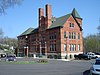
3
|
Chicago Great Western Railroad Depot
|

|
1996
|
Myrtle Street between North Madison and Vine Streets
42 ° 19 ′ 1 ″ N , 90 ° 13 ′ 21 ″ W42.316944444444 -90.2225
|
Elizabeth
|
96000098
|
|
4th
|
East Dubuque School
|
|
1982
|
Montgomery Avenue
42 ° 29 ′ 38 " N , 90 ° 38 ′ 29" W.42.493888888889 -90.641388888889
|
East Dubuque
|
82000396
|
|
5
|
Henry N. Frentess Farmstead
|

|
2011
|
19140 US Highway 20 West
42 ° 28 ′ 20 ″ N , 90 ° 36 ′ 30 ″ W.42.472222222222 -90.608333333333
|
East Dubuque
|
|
|
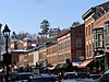
6th
|
Galena Historic District
|
|
1969
|
Galena and environs
42 ° 25 ′ 6 ″ N , 90 ° 25 ′ 40 ″ W.42.418333333333 -90.427777777778
|
Galena
|
69000056
|
|
7th
|
Ulysses S. Grant Home
|

|
1966
|
511 Bouthillier Street
42 ° 24 ′ 40 ″ N , 90 ° 25 ′ 27 ″ W.42.411111111111 -90.424166666667
|
Galena
|
66000322
|
|
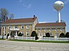
8th
|
Henry W. Miller House
|

|
2010
|
11672 West Norris Lane
42 ° 26 '48 " N , 90 ° 27' 36" W.42.446666666667 -90.46
|
Galena
|
|
|
9
|
Millville Town Site
|

|
2003
|
Apple River Canyon State Park, 8663 East Canyon Road
42 ° 26 ′ 36 ″ N , 90 ° 3 ′ 7 ″ W.42.443333333333 -90.051944444444
|
Apple River
|
03000066
|
|
10
|
Old Market House
|

|
1973
|
Market Square and Commerce Street
42 ° 24 ′ 56 ″ N , 90 ° 25 ′ 38 ″ W.42.415555555556 -90.427222222222
|
Galena
|
73000707
|
|
11
|
Old Stone Hotel
|
|
1975
|
110 West Main Street
42 ° 29 ′ 50 ″ N , 89 ° 59 ′ 28 ″ W.42.497222222222 -89.991111111111
|
Warren
|
75000665
|
|
12
|
Scales Mound Historic District
|

|
1990
|
Bounded by the local boundary of Scales Mound
42 ° 28 ′ 55 ″ N , 90 ° 15 ′ 10 ″ W42.481944444444 -90.252777777778
|
Scales Mound
|
90001199
|
|
13
|
Townsend Home
|
|
2005
|
117 North Canyon Park Road
42 ° 22 ′ 26 ″ N , 90 ° 3 ′ 3 ″ W.42.373888888889 -90.050833333333
|
Stockton
|
05000111
|
|
14th
|
Warren Commercial Historic District
|

|
1995
|
102-165 East Main Street, 204-210 East Bunett Street, 102-108 South Railroad Street
42 ° 29 '45 " N , 89 ° 59' 15" W.42.495833333333 -89.9875
|
Warren
|
95001241
|
|
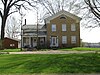
15th
|
Elihu Benjamin Washburne House
|

|
1973
|
908 3rd Street
42 ° 24 ′ 50 ″ N , 90 ° 25 ′ 54 ″ W.42.413888888889 -90.431666666667
|
Galena
|
73000708
|
|
16
|
Charles Wenner House
|

|
1984
|
Rocky Road
42 ° 27 ′ 40 ″ N , 90 ° 24 ′ 39 ″ W.42.461111111111 -90.410833333333
|
Galena
|
84001073
|
|
17th
|
WE White Building
|

|
1997
|
100 North Main Street
42 ° 21 ′ 0 ″ N , 90 ° 0 ′ 24 ″ W.42.35 -90.006666666667
|
Stockton
|
97001339
|
See also
Individual evidence
-
^ Extract from the National Register of Historic Places - Jo Daviess County.Retrieved July 12, 2012


