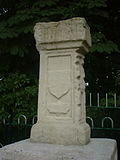
London Stone (boundary stone)
London Stone is the name of landmarks that line the Thames and Medway rivers . These stones first marked the limits of the City of London's fishing rights on the river. Over time, this resulted in administrative boundaries for shipping.
history
Until 1350, the English king had the sole right to fish in the rivers of England, and he levied a fee from those licensed by him to fish.
In 1197 Richard I , because he needed money for the Third Crusade , sold the fishing rights for the lower Thames to the City of London. Landmarks marked the extension of this right.
In Victorian times , the Lord Mayor came in procession and touched the stone in Staines-upon-Thames to renew the town's rights.
Control of the river went from the City of London to the Thames Conservancy , and below Teddington Lock to the Port of London Authority and above it to the Thames Water Authority and finally the Environment Agency .
Staines-upon-Thames
In the Middle Ages, before the canalization of the Thames, Staines-upon-Thames was the furthest point at which the tide could still be seen twice a day . Each time the water level rose by a few millimeters compared to the river sections and communities further upstream. This London Stone marks the upper end of the rights of the City of London. The official function of a landmark of the City of London Corporation was confirmed by Edward I together with the associated rights in a document in 1285 . The semicircular indentations show that it was used on the river (on the right in the photo). Here the pulling ropes of the horses that pulled the boats along the river were laid around.
Implementation of the stones in Staines upon Thames and replicas
The boundary stone in Staines has changed position several times over the years.
- Around 1750, the approximately 0.6 m high cube with its stone column was moved approximately 500 meters upstream to 51 ° 26 ′ 10.8 ″ N , 0 ° 31 ′ 18.3 ″ W in the Lammas Pleasure Ground on the river.
- In 1986 the stone was moved to the Old Town Hall Arts Center and a replica was placed in Lammas Pleasure Ground.
- In 2004 the original was brought to the Spelthorne Museum.
Appearance
The stone was worked in the lower part, resulting in a narrower base than the top. Its only inscription is the very weathered word 'STANE' in the upper half. It is the old English word for stone. The inscription is undated, but it could explain the name of the place and suggest that there were several of these stones. In the lower end of the stone there is a protective shield as a motif with an inscription that is no longer legible. The stone stands on a much wider pillar inscribed with the names of various important people in the City of London who may have participated in the moving of the stone in 1750.
Due to its location, the replica is a Grade II protected monument, partly because it stands on the site of a coal tax column .
Yantlet Creek
The downstream boundary of the right is approximately 54 km from London Bridge and is shown on both sides of the river. On the east side, the London Stone is at 51 ° 28 '34.4 " N , 0 ° 40' 39.7" E at the mouth of Yantlet Creek on the Isle of Grain .
The total height of the stone is approximately 8 meters. The column has an inscription that is no longer legible. The base of the pillar records several City of London dignitaries who were involved in the re-erection of the stone in Victorian times. Among others, there Horatio Thomas Austin and Warren stormes Hale , who for a time Lord Mayor and founder of the City of London School , was named.
Crow Stone
The stone on the north side is almost due north of the mouth of Yantlet Creek and is known as the Crow Stone (sometimes referred to as the Crowstone or City Stone). The stone is at 51 ° 32 '8.9 " N , 0 ° 40' 38.6" O at the end of Chalkwell Avenue, Southend-on-Sea . The stone was erected in 1837, replacing a smaller stone from 1755. The older stone was moved to Priory Park in Southend, where it still stands today. There has probably been a boundary stone in both places since 1285. The line between the Crow Stone and London Stone at Yantlet Creek is known as the Yantlet Line and has been used for various borders, such as the administrative boundary of the Port of London Authority.
Upnor
Two London Stones stand at 51 ° 24 ′ 46.4 ″ N , 0 ° 31 ′ 59 ″ E between the Arethusa Venture Center and the River Medway in Lower Upnor. The older stone is dated 1204 and bears the inscription "God preserve the City of London" on the reverse. Apart from that, both stones only have the names of various Lord Mayors and dates as inscriptions.
Individual evidence
- ^ GW Howe: The old limit stones of the port . In: PLA monthly . 40, 1965, pp. 282-287.
- ↑ a b Article from the Essex Countryside magazine, 1965
- ^ Spelthorne Borough Council interpretation board in Lammas Pleasure Ground
- ^ Jenny Scripps: London Stone and other boundary marks . Spelthorne Museum, 2008.
- ↑ Listing reference ( Memento of the original from October 26, 2012 in the Internet Archive ) Info: The archive link was inserted automatically and has not yet been checked. Please check the original and archive link according to the instructions and then remove this notice.
- ^ Image description on Geograph.ie
Web links
- Spelthorne Museum . Retrieved January 15, 2012.


