Spelthorns
| Borough of Spelthorne | |
|---|---|
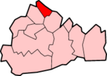
 Location in Surrey |
|
| status | Borough |
| region | South East England |
| Administration County | Surrey |
| Administrative headquarters | Staines |
| surface | 51.16 km² (298.) |
| Residents | 90,900 (257.) |
| ONS code | 43UH |
| Website | www.spelthorne.gov.uk |
Spelthorne is an administrative district with borough status in the county of Surrey in England , which borders Greater London to the east . The administrative seat is the city of Staines , in which more than half of the population lives; other important places are Ashford , Laleham , Shepperton , Stanwell and Sunbury-on-Thames . There is a city partnership with Melun in France.
The district is named after the medieval administrative unit Spelthorne Hundred , which also included villages that are now in the London Borough of Hounslow . The Borough of Spelthorne was formed on April 1, 1974 and resulted from the merger of the Staines Urban District and the Sunbury Urban District . These districts belonged to Middlesex until 1965 , but were then added to Surrey after Middlesex was almost entirely absorbed into Greater London. Another border adjustment took place in 1995 when the village of Poyle became part of the town of Slough in Berkshire .
Coordinates: 51 ° 26 ′ 0 ″ N , 0 ° 30 ′ 0 ″ W.
