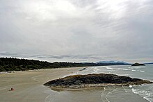
Long Beach, British Columbia
| Long Beach | ||
|---|---|---|
|
driven tree trunks on Long Beach |
||
| location | 17 km southeast of Tofino | |
| Waters | Wickaninnish Bay, Pacific Ocean | |
| Geographical location | 49 ° 3 ′ 0 ″ N , 125 ° 43 ′ 0 ″ W | |
|
|
||
| tourism | ||
| next hospital | Tofino General Hospital (17 km) | |
Long Beach is the largest and longest beach in the Pacific Rim National Park Reserve on the west coast of Vancouver Island , British Columbia , Canada . It is located on Wickaninnish Bay between Tofino (NW) and Ucluelet (SO) and borders camping and picnic areas. The British Columbia Highway 4 runs parallel to the entire beach. The beach's constant surf , exposed to the open Pacific , has made it one of the earliest and most popular surfing spots in British Columbia .
In the intertidal zone of Long Beach there are rocky islands that can only be reached at low tide. When the tide is high, the islands are either surrounded by water or hit by the waves. Furthermore, there are dangerous surf currents around the larger islands and sometimes further away in the open sea. Unattended swimming is considered risky and dangerous. As a result, access to the beach is limited in severe weather. Conspicuous signs warn of the risk of entering the beach at high tide. Logs lying around as driftwood on the coast can unexpectedly be set in motion by waves and washed up to higher areas of the beach.
Individual evidence
- ^ "Long Beach". In: Canadian Geographical Names Data Base. Geographical Names Board of Canada, accessed June 18, 2019 .
Web links
- Pacific Rim National Park Reserve on the Parks Canada website
- Long Beach trails information
- Long Beach history and natural history
- Article on Long Beach


