
Lopausee
| Lopausee | |||||||||
|---|---|---|---|---|---|---|---|---|---|
 |
|||||||||
|
|||||||||
|
|||||||||
| Coordinates | 53 ° 7 '53 " N , 10 ° 13' 48" E | ||||||||
| Data on the structure | |||||||||
| Height of the structure crown: | 44 m above sea level NN | ||||||||
| Crown length: | approx. 160 m | ||||||||
| Data on the reservoir | |||||||||
| Water surface | approx. 120,000 m² | ||||||||
| Reservoir length | approx. 800 m | ||||||||
| Reservoir width | 100-180 m | ||||||||

The Lopausee is a reservoir east of Amelinghausen in the Lüneburg Heath . The Lopau was dammed here by a dam in the 1970s to form a lake with a size of approx. 12 hectares . The dam lies parallel to the road embankment of the B209 passing by .
The lake serves exclusively as a nature area and for local recreation. The water quality is good; Fishing and swimming in the lake is possible. For the latter there is a beach and a pontoon in the lake. Visitors can walk around the lake on a 2.2 km long footpath and bike path. There is a restaurant and a pedal boat rental on the shore. For some time there has also been a high ropes course on the lake. In Lopaupark am See there is a children's playground. Every year for the traditional heather blossom festival , the lake is the stage for the grand opening fireworks display .
Picture gallery

Information panel on energy generation, February 2011
Dam

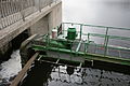
Detailed view of the weir area
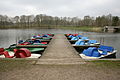
Pedal boat rental at Lopausee, February 2011


