Luegallee
| Luegallee | |
|---|---|
| Street in Düsseldorf | |
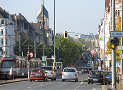
| View from Luegplatz towards Barbarossaplatz | |
| Basic data | |
| place | Dusseldorf |
| District | Oberkassel |
| Created | 1909 |
| Connecting roads | Belsenplatz, Luegplatz |
| Cross streets | Quirinstraße, Cheruskerstraße, Dominikanerstraße, Arnulfstraße, Barbarossaplatz, Schorlemerstraße, Drakestraße, Kyffhäuserstraße, Adalbertstraße, Oberkasseler Straße, Joachimstraße, Achillesstraße, Burggrafenstraße, Markgrafenstraße, Leostraße, Brend'amourstraße , Kaiser-Friedrich-Ring, Kaiser-Wilhelm-Ring |
| use | |
| User groups | Pedestrian traffic , bicycle traffic , car traffic , public transport |
| Road design | Light rail runs on green strips |
| Technical specifications | |
| Street length | 1,100 m |
The Luegallee ([ luːk- ], named after the industrialist Heinrich Lueg ) is an approximately 1 km long, 35 meters wide and lined with plane trees, street in the left-bank district Oberkassel the North Rhine-Westphalian state capital Dusseldorf .
It begins at Luegplatz shortly after the Oberkasseler Bridge and leads straight in a westerly direction over Barbarossaplatz to Belsenplatz . The Luegallee is surrounded by a four-storey building and thus additionally emphasized. On two thirds of the route is the St. Antonius Church , a solitary building that, along with the Oberkassel town hall, with the district administration of District 4 on Werner-Pfingst-Platz, has a special position in the urban structure. Barbarossaplatz is also a double square that is cut through in the middle by Luegallee. Below the Luegplatz is the main entrance to the largest annual fair on the Rhine .
history
Maps from the 1890s have names such as “Chaussee von Neuss” or “Chaussee von Crefeld”. Luegallee was inaugurated on July 17, 1909. It was created as part of an urban development project that accompanied the construction of the small railway line from Düsseldorf-Oberkassel to Krefeld by the Rheinbahn . From the outset, Oberkassel was designed as an upper-class quarter, with Luegallee forming the central traffic axis and shopping street. The Antonius Church was built between 1909 and 1910 . In the time before the First World War, spacious apartment blocks were built, such as B. 1912 the " Kyffhäuserblock ". In the first weeks after the outbreak of the First World War on August 1, 1914, Luegallee was the scene of the farewell to the soldiers who were moving to the front.
As part of the National Socialist plans for the "Gau capital Düsseldorf", the Luegallee was planned as a green area in the middle of a newly built " Kraft-durch-Freude-Stadt ". Both the plans of the National Socialists and the bombing war survived the Luegallee, just like Oberkassel as a whole, largely unscathed. When American tanks advanced on Luegallee on March 3, 1945, German troops blew up all Rhine bridges, including the Oberkassel Bridge, then known as the “ Skagerrak Bridge”. For the first time since 1898, Luegallee and Düsseldorf on the left bank of the Rhine were separated from the parts of the city on the right bank of the Rhine. At the end of 1945 an unstable pontoon bridge was set up and in 1948 a temporary solution that lasted for almost three decades. The current bridge was not put into operation until 1976.
Today, Luegallee is a busy city boulevard with a large range of goods and services as well as numerous restaurants, mostly tailored to the needs of the wealthier Oberkassel clientele .
traffic
The Luegallee, the main axis of Oberkassel, consists of two lanes over 8 m wide on both sides. The U70, U74, U75, U76 and U77 tram lines run in the middle of the street . These stop at the Luegplatz, Barbarossaplatz and Belsenplatz stops on Luegallee.
literature
- Uwe Maas, Hermann Stappmann: Architecture Guide Düsseldorf. Quarters, streets, buildings , federal government Dt. Architects, Kreisgruppe Düsseldorf (ed.), Düsseldorf 1988, pp. 59, 80f
Web links
Individual evidence
- ^ Hermann Kleinfeld: Dusseldorf's streets and their names . Grupello, Düsseldorf 1996, ISBN 3-928234-36-6 , p. 225
- ↑ Transport and beautification association for the left bank of the Rhine part of the city of Düsseldorf eV (ed.): Our century chronicle of a peninsula . Grupello, Düsseldorf 2004, ISBN 3-89978-017-5 , p. 38 ( grupello.de [PDF; 4.1 MB ; accessed on April 3, 2017]).
- ^ Hugo Weidenhaupt: Brief history of the city of Düsseldorf . 9th edition. Triltsch, Düsseldorf 1993, ISBN 3-7998-0000-X , p. 176
- ^ Hugo Weidenhaupt: Brief history of the city of Düsseldorf . 9th edition. Triltsch, Düsseldorf 1993, ISBN 3-7998-0000-X , p. 180
Coordinates: 51 ° 13 ′ 53.7 " N , 6 ° 45 ′ 19.2" E


