Rostock air station
The Rostock Luftwarte was a station for carrying out aerological measurements on the southern edge of the urban area of the Hanseatic City of Rostock . It existed from 1912 to 1945.
history
The first suggestion for a station for altitude meteorology on the Baltic Sea came from Léon-Philippe Teisserenc de Bort . On April 12, 1906, on the occasion of Alfred Hildebrandt's visit to his private air station in Trappes near Paris, the latter declared the need to create a network of air stations across the continent. This would be of great importance not only for general meteorology, but also especially for the safety of later air traffic. A site near Kolberg was proposed for the area of the Baltic Sea coast . The suggestion was rejected because Richard Assmann , director of the Royal Prussian Aeronautical Observatory , planned a station on the Danzig Bay . This was not realized until 1914.
In 1911, planning for a station on the Baltic Sea was resumed. After extensive investigations for a suitable place, the area near Warnemünde appeared to be technically suitable and far enough away from the kite station of the Deutsche Seewarte in Hamburg . The reason for choosing Rostock was that even then a seaplane base in Warnemünde was under discussion. In December 1911, the final decision was made to build. No state funds should be used, so they asked wealthy “friends of aviation” for donations. The British pioneer and promoter of aviation Patrick Young Alexander provided 20,000 marks, the city of Rostock 1,000 marks in cash. Operation was only planned for three years; any further use should then be made through state funds.
Air-electrical research, which had previously been neglected, was mainly planned. The Rostock professor of physical chemistry Gottfried Kümmell (1866–1922) took over the scientific management on a voluntary basis. He immediately began planning the selection of the building site. In order to use the available funds for scientific work as much as possible, an application was made to the City Council of Rostock to obtain a place for the air station free of charge. This was "willingly" approved by the magistrate and the local council. The search for a suitable place in the Rostock area began, where the kites and tethered balloons can be let into the air. The choice fell on the highest point in Rostock, an area near Friedrichshöhe in the Barnstorfer Forest , which was owned by the city. The construction site had a size of about 2.5 hectares.
After Gottfried Kümmell had completed the space requirements and the layout plan for the workshop building, the dragon and balloon hall, the air-electric hut, the winch house, etc., the Berlin builder Willy Jäger took over the implementation planning. The construction was carried out by the Rostock master mason Quade. The city had a high-voltage line laid on the site at its own expense for the power connection. The scientific equipment was set up in September 1912 and the first measurement kites could be mounted by the end of November. On December 5, 1912, locals, representatives of the city of Rostock and other official personalities visited the finished site. The Deutsche Seewarte actively supported the start of the work by training unskilled workers and kite carpenters, as well as by procuring a motor winch for the climbs. The air observatory also received great help from the Royal Prussian Aeronautical Observatory in Lindenberg, where employees were trained and trained.
The International Commission for Scientific Luftschiffahrt welcomed its 7th meeting from May 28 to June 1, 1912 in Vienna, the establishment of Rostock air observatory. The decision in question stated: “The commission thanks Mr. Hildebrandt, the founder, and in particular Mr. Patrick Y. Alexander, the generous donor of the Rostock air station, for having succeeded in establishing an aeronautical station that is part of the work of the international commission participate and above all want to make air-electrical measurements also at altitude. "
After Gottfried Kümmell's death in 1922, Günther Falckenberg succeeded him as director of the air station. He held the office until it was dissolved in 1945.
location
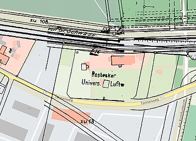
The site of the Luftwarte was on the southwestern outskirts of Rostock and 11.5 kilometers south of the Baltic Sea coast on the highest point near the city. At the highest point of the air station a height of 48 m above sea level was given. The area of the entire site was about 2.5 hectares. An adjacent military training area could also be used for kite ascents. The site borders on the Wismar – Rostock railway to the south . The nearby 15 KV overhead line from Rostock-Bramow to Güstrow was protected from contact with kite wires by overstretched, earthed copper wires. The area adjacent to the railway with the station building, kite and balloon hall, the system for air-electric measurements and thermometer hut was fenced, the winch house was freely accessible 80 meters south of the balloon hall.
When comparing the land map from 1930, on which the air station is entered with the house number 2, with today's city map, it can be seen that some of the old buildings are probably identical to today's. Today it is used as a residential building with the address Tannenweg 29 .
An allotment garden located north of the railway line near the Westfriedhof is still called the "Luftwarte" today.
literature
- A. Hildebrandt, G. Kümmell: The work of the “Rostocker Luftwarte” in Friedrichshöhe near Rostock in 1913. In: Meeting reports and treatises of the natural research society in Rostock. New episode . Volume 6, 1914/15 (published 1916), pp. 65-110. Digitized
Individual evidence
- ^ Entry in the Catalogus Professorum Rostochiensium
- ↑ Reinhard Mahnke: The Rostocker Luftwarte 1912 - 1945 . Calendar sheet June 2016 at www.physik.uni-rostock.de
Coordinates: 54 ° 4 ′ 30.6 ″ N , 12 ° 4 ′ 19 ″ E

