Lukenie
| Lukenie | ||
|
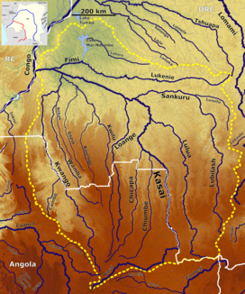
The Lukenie in the catchment area of the Kasai (top center) |
||
| Data | ||
| location |
|
|
| River system | Kasai | |
| Drain over | Fimi → Kasai → Congo → Atlantic | |
| source | a few kilometers north of Katako-Kombe | |
| Source height | approx. 550 m | |
| muzzle | in the Fimi near Kutu coordinates: 2 ° 43 ′ 48 ″ S , 18 ° 9 ′ 20 ″ E 2 ° 43 ′ 48 ″ S , 18 ° 9 ′ 20 ″ E |
|
| Mouth height | 288 m | |
| Height difference | approx. 262 m | |
| Bottom slope | approx. 0.29 ‰ | |
| length | 900 km | |
| Small towns | Oshwe | |
The Lukenie is a river in the west of the Democratic Republic of the Congo . With its estuary, the Fimi , it has a length of about 1060 km.
course
The river has its source in the province of Sankuru a few kilometers north of Katako-Kombe at about 550 meters above sea level. It flows in a relatively straight line from east to west. The Lukenie flows into the Fimi opposite Kutu , shortly after it has left Lake Mai-Ndombe .
ID
Depending on the source, the Fimi is named as a continuation of the Lukenie from the mouth of the Mai-Ndombe Lake, or the Lukenie as a tributary of the Fimi. The two rivers are sometimes combined as the Lukenie-Fimi.

