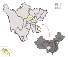
Luojiang (Deyang)
Luojiang ( 罗 江区 , Luójiāng Qū ) is a municipality in the prefecture -level city of Deyang in the Chinese province of Sichuan . It is located in the northeast of the Chengdu Plain and has a size of 448 ² with an east-west extension of 35 km and north-south extension of 25 km. At the end of 2012 it had around 250,000 inhabitants. It borders on Fucheng to the east, Zhongjiang to the south, Jingyang to the south and west, and Mianzhu to the northwest .
Loujiang is located in a subtropical climate zone. It is characterized by an early but unstable spring, a damp summer, a rainy autumn with rapidly falling temperatures and a dry winter with relatively little frost. The annual average temperature is 16.5 ° C, the annual precipitation is 910 mm. There are an average of 278 frost-free days per year. Loujiang is part of the area that is irrigated by the Dujiangyan irrigation system . The main river in Loujiang Territory is the Kai Jiang .
Luojiang is rich in natural resources. There are deposits of more than a billion cubic meters of natural gas , as well as slate , peat , bentonite , construction sand and clay .
In terms of transport, the area is served by the Baoji – Chengdu railway line , the Beijing – Kunming motorway and the 108 national road.
The ancestral hall and the tomb of Pang Tong ( Pang Tong ci mu庞统 祠墓) have been on the list of monuments of the People's Republic of China (6-721) since 2006 .
Administrative structure
At the community level, the city district consists of ten large communities . These are:
- Greater community Wan'an (万安镇);
- Greater community Yanjia (鄢家镇);
- Greater community Jinshan (金山镇);
- Greater community Lüeping (略坪镇);
- Greater community Yuying (御营镇);
- Greater community Huijue (慧觉镇);
- Greater community Tiaoyuan (调元镇);
- Greater community Xinsheng (新盛镇);
- Greater community Panlong (蟠龙镇);
- Greater community Baimaguan (白马关镇).
At the village level there are 102 villages and 25 municipalities.
The borough's government is located in Wan'an Parish .
Web links
- Official Website (Chinese)
- Info page (chinese)
- Pang Tong's tomb in Luojiang county, Sichuan
Individual evidence
- ↑ a b c d e 罗 江 概况.中共 德阳 市 罗 江 区委 办公室, May 3, 2018, accessed on August 24, 2018 (Chinese).
- ↑ a b c d 罗江县 概况 地图.行政 区划 网, May 13, 2015, accessed on August 24, 2018 (Chinese).
Coordinates: 31 ° 20 ' N , 104 ° 32' E
