
Lurgenstein's garden

Lurgenstein's garden (formerly Heinsbergs Garten , Jöchers Garten ) was a Baroque garden in Leipzig , which was incorporated into urban development in the 19th century.
Location and shape
Seen from the city, the garden lay across the Pleißemühlgraben behind the Thomasmühle on the western edge of the old town. It formed roughly a rectangle that ended in a point to the northeast. It was bordered on the east by the Pleißemühlgraben and on the other sides by the Diebesgraben . This was followed by the Kleinbosische Garten in the west, the Reichelsche Garten (formerly Apels Garten ) in the south and the Place de repos in the north . The parts of the Thomasmühle beyond the Pleißemühlgraben did not belong to the garden. The garden was reached via a footbridge from the promenade over the Pleißemühlgraben.
Based on today's conditions, the area of the garden between Dittrichring and Zentralstraße must be paved.
On a map of Leipzig from 1830 it can be seen that only the southern part of the garden was baroque in character, the northern part was a meadow garden. Nor did it display the splendor of its famous neighboring gardens.
history
The garden was laid out in the 17th century. It was called after its owner, among them Heinsberg, Jöcher and others. In 1834 the comb manufacturer and city councilor Wenzel Anton Lurgenstein bought it. At this point in time, the area had already been expanded and residential complexes had already been built in the neighboring Reichel Garden. It can therefore be assumed that Lurgenstein saw the garden primarily as a building site. Because already in the years 1837 to 1840 he had a residential complex with five houses built in the south-western part by the council builder Johann Heinrich Walther.
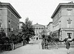
The residential development in Lurgenstein's garden behind the Pleißemühlgraben, around 1885

Felix Mendelssohn Bartholdy's apartment, marked
on a postcard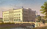
The Central Hall on the grounds of Lurgenstein's Garden, around 1850
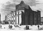
The Great Synagogue on Centralhallenstrasse


A spur road branching off from the promenade over a bridge over the Pleißemühlgraben led directly to the pillared three-story main building. It was flanked by two buildings each, which were connected at the back by a narrow transition building. Due to the addresses that were created in this way, Lurgenstein's garden kept the name, although it no longer described a garden.
One of the first and most prominent residents was Felix Mendelssohn Bartholdy . In October 1837 he came from Frankfurt am Main with his wife Cécile , whom he had married there in March, and rented a room on the first floor of the left front building with a view of the St. Thomas Church.
The Central Hall , a multi-purpose building for events and exhibitions , was built in the northern part of the garden in 1849 . The Central Hall had to give way to its successor as early as 1898. Centralhallenstrasse was laid out in the rear part of the garden area (today Zentralstrasse, front part Gottschedstrasse). Of 1853/1854 was based on plans of her Semper -Schülers Otto Simonson , the Leipzig synagogue of the Jewish Community of Leipzig . It was destroyed on Kristallnacht 1938.

During the Second World War , the area of the former Lurgenstein Garden was almost completely destroyed. Only the Kosmos exhibition center, built in 1925, and a few residential buildings on Gottschedstrasse were preserved. During the GDR era, a building for a data center was built in the area of the former Central-Halle and a number of prefabricated houses on Zentralstrasse . On the site of the former residential complex and the Thomasmühle, which was also destroyed, an administrative center of the Dresdner Bank (today: Commerzbank) was built from 1994 to 1996 .
Lurgenstein is only reminiscent of Lurgenstein's footbridge , a footpath along the reopened Pleißemühlgraben .
literature
- Inner Westvorstadt - A historical and urban study . Published by PRO LEIPZIG 1998
- Horst Riedel: Stadtlexikon Leipzig from A to Z . PRO LEIPZIG, Leipzig 2005, ISBN 3-936508-03-8 , p. 374
Web links
- Lurgenstein's garden in the Leipzig Lexicon
Individual evidence
- ↑ Leipzig Lexicon
- ^ SLUB Dresden map forum
- ↑ Time Online
- ^ Gina Klank, Gernot Griebsch: Lexikon Leipziger Straßeennamen , Verlag im Wissenschaftszentrum Leipzig, 1995, ISBN 3-930433-09-5 , p. 228
Coordinates: 51 ° 20 ′ 21 ″ N , 12 ° 22 ′ 12 ″ E