Lyngen Alps
| Lyngen Alps | ||
|---|---|---|
|
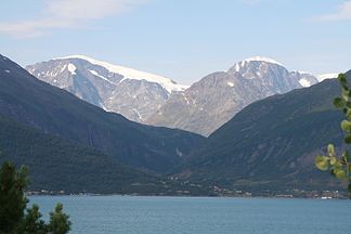
Jiehkkevárri (left), the highest mountain in the Lyngen Alps |
||
| Highest peak | Jiekkevárri ( 1834 moh. ) | |
| location | Troms og Finnmark , Norway | |
| part of | Scandinavian mountains | |
|
|
||
| Coordinates | 69 ° 29 ′ N , 19 ° 52 ′ E | |
The Lyngen Alps ( Norwegian Lyngsalpan (official), also Lyngsalpene or Lyngsfjellan ) are part of the Scandinavian Mountains in Northern Norway.
They are located on the Lyngen peninsula in the Fylke (province) Troms og Finnmark , extend over 90 km in a north-south direction and are 15-20 km wide. In the west they border on the Ullsfjord and in the east on the Lyngenfjord . Approximately in the middle, a tributary of the Ullsfjord, the Kjosen , cuts about 14 kilometers deep from west to east into the mountain range. The highest peak of the Lyngen Alps is Jiekkevárri , located south of the cut, with 1834 moh. The British alpinist William Cecil Slingsby was the first to climb several peaks .
The Lyngen Alps are little developed for tourism, but are still visited by mountain hikers and extreme skiers.
Web links
Individual evidence
- ^ Anthony John Dyer, John Baddeley, Ian H. Robertson: Walks and Scrambles in Norway , Cordee Ltd, 2006, ISBN 9781904466253
- ↑ Lyngsalpene in Store norske leksikon . Retrieved February 6, 2016

