
Mülheim city garden

The Mülheimer Stadtgarten , located in the Cologne-Mülheim district , was created in 1912/13. Its current shape is essentially based on the design by the garden architect Theodor Nussbaum from 1928.
location
The Mülheimer Stadtgarten is located east of the Bergischer Ring road, between Lassallestrasse in the south and Wiener Platz in the north. Its main entrances are on Jan-Wellem- Strasse (formerly known as Strundener Strasse) , which borders the garden on its east side . There are several small streets on this, such as Fürstenbergstraße, Merkerhofstraße, Sonderburger Straße and Vincenzstraße, whose names refer to the history of the garden.
history


The area of today's city garden was a shallow depression of the Strundener Bach , through whose power a mill belonging to the Merkerhof was driven. The Merkerhof, which was owned by the noble family of Barons von Fürstenberg , was probably leased after the von Fürstenbergs had acquired property in Stammheim in 1818 and later came to the then still independent town of Mülheim am Rhein . At the beginning of the 20th century, the city fathers of Mülheim considered converting the site into an urban garden.
The name of Vincenzstraße refers to the garden architect and cemetery administrator "Joseph Vincentz", who lived in an office building in the old Mülheim cemetery on Sonderburger Straße . Vincentz, who also became cemetery inspector in Cologne in 1916, was commissioned to design the Mülheim city garden in 1906.
Plant the garden
Fritz Encke, who was appointed gardening director in neighboring Cologne in 1903, was a recognized gardening specialist and was open to reform ideas in gardening art. His example of creating real “public gardens” without lattice fences, in which, for example, walking on the lawns was not forbidden, but even allowed to play ball on them, also caught on in other places.

City hall park side

Pond waters
Memorial against all violence

Animal or fairy tale fountain by Wilhelm Albermann at the southeast entrance


Water, meadows and trees
The first facility, with a smaller area than today, was built in 1912 and 1913. In the hollow, in which there was also a mill pond, a small, asymmetrically shaped lake with a fountain was created , surrounded by wide meadows. These were only planted selectively with trees, the species of which were preferably oak , beech , birch , ash and alder , evergreen shrubs and conifers . The latter also set colorful accents in winter. At its edges with the main paths surrounding it, the garden was bordered all around with trees and bushes. Wealthy Mülheim citizens donated the construction of a tea house in 1916 , which was integrated into the garden as a result of the later expansion of the garden.
rose Garden

The three-part rose garden at the south end of the garden extended, starting at the corner of Charlierstrasse, parallel to Lasallestrasse over the entire width of the garden. The ornamental garden had a central water lily basin and a central square surrounded by ornamental apple trees. The Märchenbrunnen was built in 1914 above the south-eastern garden area, up the slope at street level opposite Sonderburger Strasse. He realized the design of the Cologne sculptor Wilhelm Albermann, who died the year before .
During the great unemployment that also prevailed in Cologne in 1928, the garden was extended in a northerly direction to Wiener Platz as part of the so-called “emergency work” by the unemployed. Theodor Nussbaum, who was in charge of the design office of the Cologne garden administration, was responsible for the design and planning of the extension. In the 1930s, a rather emerged at the Jan Wellem road oversized down into the garden leading staircase that in the following years, the Sunday parade of the Hitler Youth served.
Today's garden


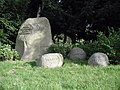
The tea house in the city garden was destroyed in the Second World War; today's city hall was built on its site. The original location of the Jan Wellem monument was on the south side of Wiener Platz. After the Second World War, the monument to the Stadtgarten was relocated opposite the confluence with Fürstenbergstraße, to the side in front of the garden staircase. In 1984 an unconventional work of art was placed at the first entrance on Jan-Wellem-Straße. It consists of a group of stone blocks (presumably weathered wool sacks ), each of which is labeled as a warning against all types of violence. A large playground for toddlers on the northwest side provides shade under old trees. The paths in the garden are well-kept, and there are also enough benches to rest. The traffic noise of a big city is hardly noticeable.
Only a few shortcomings are apparent to visitors to the garden. The pond shows strong algae formation , there are no flower plantings (beds or at the edges of the path). The area of the former rose garden and its symmetrical borders have been preserved and clearly recognizable, but today it is made of grass.
literature
- Joachim Bauer, Carmen Kohls: Cologne under French and Prussian rule . In: Werner Adams, Joachim Bauer (Hrsg.): From the botanical garden to urban green - 200 years of Cologne green . Bachem Verlag, Cologne 2001, ISBN 3-7616-1460-8 , ( Stadtspuren - Denkmäler in Köln 30).
Web links
Individual evidence
- ↑ a b Henriette Meynen, 'Mülheimer Stadtgarten': In Joachim Bauer and Carmen Kohls: Cologne under French and Prussian rule . In: Werner Adams and Joachim Bauer (eds.): From the Botanical Garden to Big City Green - 200 Years of Cologne Green (Stadtspuren - Denkmäler in Köln, Volume 30.) p. 146.
- ^ Gertrud Scholz: Mülheim municipal cemetery : In Joachim Bauer and Carmen Kohls: Cologne under French and Prussian rule . In: Werner Adams and Joachim Bauer (eds.): From the Botanical Garden to Big City Green - 200 Years of Cologne Green (Stadtspuren - Denkmäler in Köln, Volume 30.) p. 104.
- ↑ History and Heimatverein Rechtsrheinisches Köln: Yearbook for History and Regional Studies Volume 8 , self-published, Cologne 1982, p. 49
Coordinates: 50 ° 57 ′ 29.6 ″ N , 7 ° 0 ′ 17.9 ″ E