
Strunde
|
Strunde Strunder Bach |
||
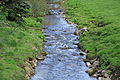
 In some areas, like here in the Maria-Zanders-Anlage , the Strunde flows openly through the town center of Bergisch Gladbach. |
||
| Data | ||
| Water code | DE : 273568 | |
| location | North Rhine-Westphalia ; Germany | |
| River system | Rhine | |
| Drain over | Rhine → North Sea | |
| source | in the Bergisch Gladbach district of Herrenstrunden 51 ° 0 ′ 28 ″ N , 7 ° 10 ′ 59 ″ E |
|
| Source height | 155 m above sea level NN | |
| Spring discharge |
MQ HHQ |
50 l / s 830 l / s |
| muzzle | in the Cologne district of Holweide at the so-called brook crossing in the Faulbach Coordinates: 50 ° 57 ′ 46 ″ N , 6 ° 59 ′ 48 ″ E 50 ° 57 ′ 46 ″ N , 6 ° 59 ′ 48 ″ E |
|
| Mouth height | 35 m above sea level NN | |
| Height difference | 120 m | |
| Bottom slope | 6.5 ‰ | |
| length | 18.5 km (15 km to the inlet in the Faulbach ) | |
| Catchment area | Bergisch Gladbach 81.21 km² | |
The Strunde or the Strunder Bach is a right tributary of the Rhine in North Rhine-Westphalia . The source of the Strunde lies in the Bergisch Gladbach district of Herrenstrunden , which is named after her. Today it flows into the Rhine via the Cologne sewer system on the right bank of the Rhine.
At the time of industrialization, the Strunde was an important source of water and energy for the region.
geography
Strundequelle


According to general opinion, the Strunde rises from a karst spring about 100 meters northeast of the parish church of Herrenstrunden . Bubbles rising from below indicate the escape of water. This source pours an average of about 50 l / s, sometimes up to 830 l / s.
course
But the valley of the Strunde begins about two kilometers further to the northeast. In a karst area between the villages of Oberblissenbach above the beginning of the valley, Spitze on the northwest and Eikamp on the ridge to the south, individual springs come up in a basin at various points, whose outflow, depending on the weather, tends towards the main spring in small rivulets and streams.
The Strunde flows further south-west to west-south-west towards the Rhine and crosses the closed development of Bergisch Gladbach, where it runs vertically on a section . In the city center of Bergisch Gladbach, individual parts of the Strunde have been exposed in recent years. There part of the water flows through the bed of the former Umbach, which used to supply the paper mills with water. From Richard-Zanders-Straße, the Strunde usually flows openly in its old bed. Further to the west, it crosses the urban area of Cologne on the right bank of the Rhine and mostly openly crosses the Dellbrück and Holweide districts . Shortly before it crosses the A 3 , it flows over the Faulbach at an intersection structure . After another piece in the corridor after that, it reaches the edge of the buildings in Cologne-Buchheim , where it is fed into the municipal sewage system on the tram route of line 3 opposite the end of Arnsberger Strasse.
The Strunder Bach once ended in the floodplains of the Rhine without reaching the river itself. The Bachstrasse in Mülheim reminds of the lower course, which leads directly south of the Mülheimer Brücke to just before the Rhine.
Tributaries
The tributaries of the Strunde are listed below, with the orographic location as well as the length and location of the mouth
- Rosenthaler Bach , right, 1,267 m, in Herrenstrunden
- Asselborn Bach , left, 2,703 m, in Herrenstrunden
- Hombach , left, 2,399 m, at Gut Schiff
- Hebborner Bach , right, 3,421 m, in Bergisch Gladbach near Cederwaldstraße with the tributary Kuckelberger Bach
- Lerbach , left, 5,410 m, in Bergisch Gladbach near the Cederwaldmühle
- Rodenbach or Scheidtbach , approx. 4,400 m, in Bergisch Gladbach- Gronau
- Hasselbach , left, 2,656 m
history
Originally the Strunde, which came from Herrenstrunden , seeped away from the Rhine in the Thielenbruch marshland. In the 6th century, the stream bed was artificially lengthened to the river and the swamp area was drained. The extended Strunde flows north of the former swamp area, the also artificially created Faulbach , a branch of the Strunde, in the south. The former drainage ditches were then used by the farmers to irrigate their meadows and fields during drought. Some of these trenches and the associated lock gates have been preserved to this day. One can be found near the Isenburg , another a little further down the stream in Holweide closer to the Wichheimer Mühle ; the adjoining street Am Flutgraben delivers the memory of it by name. The flood ditch at the mill was used in winter in the 1960s to turn the adjacent meadow into an ice rink ; today the Holweider Comprehensive School on Burgwiesenstrasse is located on this site .
Because the town of Bergisch Gladbach grew rapidly, the Strunder Bach was finally piped up here and led underground. This section begins shortly before the Bergisch Gladbach city center, the Verdolung is only interrupted in a few places. The creek also partly takes the route through Cologne on the right bank of the Rhine. After several heavy rain events in 2000 and 2001, the sewerage system could no longer absorb the amount of rain that had accumulated, which resulted in large parts of Bergisch Gladbach's inner city being flooded. Comprehensive construction measures in the form of rain retention basins were developed against this.
Numerous hollow willows grow on the banks of the Strunde, from which the name of the Cologne district of Holweide is derived. Braided willow was used to stabilize the bank walls, the willow can still be seen in places. In order to obtain a large height difference to drive further mills, the Strunde near Gut Schlagbaum was led over a small aqueduct over the Faulbach. Gut Schlagbaum is located near the Schlagbaumer Weg and used to be the border station between the free imperial city of Cologne and the county of Berg .
At the moment (summer 2012) the Strunde flows with a steep gradient into the Faulbach. This connecting channel creates a small peninsula. Rare crayfish have buried themselves in hidden places in the banks of the Strunde . When the aqueduct is completed (see bridge structure in the background of the picture), the Strunde should flow off again in its own sewer system.
In the upper reaches of the Faulbach bears the name Flehbach . There he drove the oriel mill on the Mauspfad and the Flehbachmühle in Refrath . Crayfish also live in the Faulbach. When the KVB briefly drained the Faulbach while building its signal box in Merheim, Merheim residents are said to have saved the protected species in their bathtubs.
The aqueduct, which was built from bricks in the 19th century, was built using a round arch construction, it replaced the medieval wooden building. At the end of the 1970s, this cultural monument was replaced by a concrete bridge. At this point in time there was still a last biotope of the former swamp fauna near this bridge . Today the sports field of the SC Holweide from 1968 eV and an allotment garden have been built there.
The strunde from Cologne-Buchheim to the Rhine has been underground since 1906. Today there are no intentions and no possibilities to let the strunde in the Mülheim area run in daylight again. However, the continuity of the Strunde should be traced via a green connection. One building block for this is the connection from the Rhine promenade to Wiener Platz.
The Strunde was involved in several regional projects in 2010 :
- In the # 01 RegioGrün project , a total of 6 cycling and hiking trails were identified. A route as close as possible along the Strunde from the Rhine in Cologne-Mülheim up to the source in Herrenstrunden was marked as the East Adventure Route.
- In the regional project # 07 Designing the City of Bergisch Gladbach , a. about the disclosure of the Strunde in the area of the eastern city center combined with the expansion of the surrounding open spaces. The city has taken this measure together with other projects, e.g. B. for flood protection and sewage disposal, combined for the construction project Strunde hoch vier .

The strunde shortly after the source

Underpass in Herrenstrunden
The strunde below Herrenstrunden

The tour at the Igeler Mühle

The last part of the Strunde in the streambed of the former Umbach before it flows into the Strunde Canal

The mouth of the Umbach der Strunde in the Strunde Canal,
on the right Villa Zanders
The aqueduct, the Strunder Bach on the Faulbach leads


Industrial use
The mills, at times 36 were in operation at the same time, and the water itself ensured economic prosperity in Bergisch Gladbach and mainly promoted the paper industry (see Zanders paper factory ), an industry that is still important for this city today. At the eastern exit of Bergisch Gladbach, the Alte Dombach paper museum shows how paper was made on the Strunde in the past. In the Holweid suburb of Schweinheim, there was a wool dyeing factory until the early 1980s that diverted its wastewater into the Strunde. Depending on the order situation, the color of the stream also changed. The yield was 1.189 m 3 / s with a difference in altitude of 94 m to the mouth (source about 140 m above sea level, mouth about 46 m above sea level).
On Bachstrasse in Mülheim, the Greven brewery (today: Gilden) used the water from the Strunde.
The mills on the round
The literature on the mills on the Strunde is extensive . Nobody can say exactly how many there were in total. Around 1846 there were 51 mills that were listed. Only the Iddelsfeld mill is completely preserved today .
See also
Individual evidence
- ↑ a b Google Earth
- ↑ Kölner Stadtanzeiger of December 29, 2011: The Strunde does not go under .
- ↑ a b Ulrich Jux: Geology and landscape areas in the catchment area of the Strunde in: Heimat between Sülz and Dhünn, history and folklore in Bergisch Gladbach and the surrounding area . Bergischer Geschichtsverein Rhein-Berg e. V., Issue 4 1997, p. 22 ff.
- ^ A b Karl Hermes and Heinrich Müller-Miny: The districts in North Rhine-Westphalia, Volume 8, Der Rheinisch-Bergische Kreis , Wilhelm Stollfuß Verlag Bonn 1974, p. 44
- ↑ Water directory of the State Office for Nature, Environment and Consumer Protection NRW 2010. Accessed on February 27, 2017 .
- ↑ Herbert Nicke : Bergische Mühlen, On the trail of the use of water power in the land of a thousand mills between Wupper and Sieg . Wiehl 1998, p. 246, ISBN 3-931251-36-5 .
- ↑ All projects of the Regionale 2010 at a glance. Retrieved July 26, 2017 .
- ↑ Adventure route east - from the Rhine to the source of the Strunde. Retrieved July 26, 2017 .
- ↑ Background and description of the “Strunde hoch vier” construction project. Retrieved July 26, 2017 .
- ↑ Vincent von Zuccalmaglio : History and description of the city and the district of Mülheim a. R. Cologne 1846 p. 203 f.
literature
- Ferdinand Schmitz : The paper mills and paper makers of the Bergisch Strundertal . Bergisch Gladbach 1921.
- Determination and order for the Strunderbach, printed by Chr. Illinger, Bergisch Gladbach o. J., (it concerns the Bach order and the Bach protocol from 1823 after a copy from 1854).
- Paul Rothhäuser: Between Faulbach and Strunde . Cologne-Mülheim 1969.
- Frank Schulte: "The Mills on the Strunde". Publishing house Dr. H. Wamper GmbH (Bergisch Gladbach, 1979), ISBN 3-932326-02-4 .
- Klara von Eyll: 400 years of paper mills on the go . Bergisch Gladbach 1982.
- Herbert Stahl : "The meadow economy on the Strunde" in: Heimat between Sülz and Dhünn, issue 3, 1996 (BGV Bergischer Geschichtsverein Rhein-Berg, Bergisch Gladbach)
- Herbert Stahl (editor) and others: Gronau . Series of publications by the Bergisches Geschichtsverein Rhein-Berg e. V., Volume 51, Bergisch Gladbach 2007, ISBN 978-3-932326-51-6 .
- Hans Leonhard Brenner : The Strunde and their Bergisch Gladbacher mills . Ed. from the Bergischer Geschichtsverein Rhein-Berg e. V. in cooperation with the Bergisch Gladbach City Archives, Bergisch Gladbach 2012, p. 94 ff. ISBN 3-932326-67-9 .
- Thomas Kreft: The Strunde. Historical hydraulic engineering under the EU Water Framework Directive . In: Rheinische Heimatpflege , vol. 57 (2020), no. 1, pp. 53–60.
- A. Görgens: The Strunderbach yesterday, today, tomorrow . Heimatverein Köln-Dellbrück e. V. "Ahl Kohgässer", Rheinland-Druck GmbH, Cologne-Dellbrück o. J.
Web links
- Tag der Strunde September 5, 2010 (PDF; 1.5 MB) accessed on October 13, 2011
- The Strunderbach and its mills, Heimat-Verein Köln-Dellbrück e. V., accessed on October 13, 2011.
- The Strunde does not go under, Kölner Stadt-Anzeiger from December 29, 2011, accessed on January 6, 2013.