
Flehbach
|
Flehbach (lower course: Faulbach ) |
||
 Confluence of the Flehbach (front) and Bruchbach (right) |
||
| Data | ||
| Water code | DE : 27356 | |
| location |
Bergische plateaus
|
|
| River system | Rhine | |
| Drain over | Rhine → North Sea | |
| source | Area of the Tütberg in the Königsforst 50 ° 56 ′ 14 ″ N , 7 ° 10 ′ 22 ″ E |
|
| Source height | approx. 160 m above sea level NHN | |
| muzzle |
Cologne-Mülheim coordinates: 50 ° 58 ′ 7 ″ N , 7 ° 0 ′ 3 ″ E 50 ° 58 ′ 7 ″ N , 7 ° 0 ′ 3 ″ E |
|
| Mouth height | approx. 48 m above sea level NHN (Rhine mouth of the Faulbach) | |
| Height difference | approx. 112 m | |
| Bottom slope | approx. 6.6 ‰ | |
| length | 16.9 km with Faulbach | |
| Catchment area | 76.785 km² | |
The Flehbach is a 17 km long right tributary of the Rhine .
geography
course
The Flehbach is formed from several source rivers mainly from the northwest slope of the Tütberg in the urban area of Bergisch Gladbach . The smallest source streams are nameless, the somewhat larger ones are called Wahlbach , Holzerbach and Kleiner Wahlbach . The Böttcherbach , which rises in the Moitzfeld area, joins from the north. Over a length of around 2 km, the Flehbach forms the city boundary between Bergisch Gladbach and Cologne . In Cologne-Merheim it flows together with the right Bruchbach , which was previously also known as Eggerbach and Frankenforstbach . The combined stream is called Faulbach , crosses under the Strunde and flows canalised into the Rhine.
Tributaries
|
Stat. in km |
Surname | GKZ | location | Length in km |
EZG in km² |
|---|---|---|---|---|---|
| 13.8 | Böttcherbach | 27356-12 | right | 4,614 | 1.711 |
| 11.8 | NN | 27356-132 | right | 1.443 | 0.845 |
| 9.7 | NN | 27356-134 | Left | 3.141 | 1,426 |
| 8.8 | Selbach | 27356-4 | Left | 5.06 | 4.658 |
| 4.9 | Frankenforstbach ( Bruchbach ) | 27356-6 | right | 9,566 | 18.065 |
| 3.2 | Strunde | 27356-8 | right | 15.955 | 35.913 |
Retention
After rainfall, the Flehbach absorbs large amounts of water. In the past it flooded Cologne-Rath , which lies on an old arm of the Rhine. The Flehbachdamm in the Königsforst regulates the runoff, as well as smaller overflow basins in the lower course.
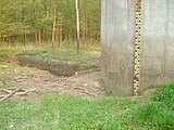
Flehbachdamm and Flehbach ...
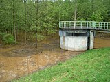
... after heavy rain


River history
The Flehbach used to drive several water mills. Only the street name Flehbachmühlenweg in Lustheide reminds of the Flehbacher Mühle . The mill pond is still preserved from the oriel mill behind the Flehbachdamm.
Originally the brook flowed in Mülheim in the direction of Düsseldorfer Straße to Wiesdorf . Because of the floods, it was led directly to the Rhine through an artificial bed in Mülheim at the beginning of the 19th century. The name Bachstrasse is a reminder of this.
Individual evidence
- ↑ a b Ewald Glässer: Geographical land survey: The natural spatial units on sheet 122/123 Cologne / Aachen. Federal Institute for Regional Studies, Bad Godesberg 1978. → Online map (PDF; 8.7 MB)
- ↑ a b ELWAS specialist information system, Ministry for Climate Protection, Environment, Agriculture, Nature and Consumer Protection North Rhine-Westphalia ( notes )
- ↑ a b c Water directory of the State Office for Nature, Environment and Consumer Protection NRW 2010 (XLS; 4.67 MB) ( Notes )
- ↑ Topographical Information Management, Cologne District Government, Department GEObasis NRW ( Notes )
- ↑ The Flehbach crosses under the Strunde. A small part of the Strunde flows towards the Flehbach.
- ↑ Vincenz Jacob von Zuccalmaglio: History and description of the city and the district of Mülheim aR: To the advantage of the Cologne cathedral building . Feilner, 1846.
Web links
- From Fleh- zum Faulbach, Kölner Stadt-Anzeiger from June 12, 2012, accessed on June 16, 2013
- Dispute over brook and one-way street, Kölner Stadt-Anzeiger from June 12, 2012, accessed on June 16, 2013