Wiesdorf
|
Wiesdorf
City of Leverkusen
|
|
|---|---|
| Coordinates: 51 ° 2 ′ 7 ″ N , 6 ° 58 ′ 32 ″ E | |
| Height : | 45 m |
| Area : | 9.86 km² |
| Residents : | 18,174 (May 31, 2013) |
| Population density : | 1,843 inhabitants / km² |
| Incorporation : | 1930 |
| Postal code : | 51373 |
| Area code : | 0214 |
|
Location of Wiesdorf in Leverkusen
|
|
Wiesdorf is a district of Leverkusen . On an area of 986 ha it has 18,174 inhabitants (May 31, 2013), the population density is 1843 inhabitants per km².
location
Wiesdorf borders Manfort in the east . Chempark is in the south . Wiesdorf borders the Rhine to the west . In the north, the Dhünn flows from east to west and the Bürrig district is located .
History and Development
During the Middle Ages, in 1107, Wiesdorf was first mentioned in a document as Wistubbe . Already in 1190 the place had a parish church. Located close to the Rhine, Wiesdorf was also exposed to loads from the river. In the February flood in 1571, the Rhine not only changed its course, but also destroyed houses and the Catholic Church. When Wiesdorf was again destroyed by a flood of the Rhine in 1657, the town was rebuilt further east.
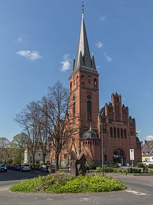
In 1666 the Catholic Church of St. Anthony was built. Politically, Wiesdorf has belonged to the Miselohe office in the Duchy of Berg since the Middle Ages . From 1806 to 1813 the place belonged to the Napoleonic Grand Duchy of Berg , the Mairie Schlebusch was created , to which Wiesdorf also belonged. In 1815 Wiesdorf came to the Kingdom of Prussia and became part of the Schlebusch mayor in the district of Opladen in the administrative district of Düsseldorf . In 1820 Wiesdorf moved from the mayor's office Schlebusch to the mayor's office in Opladen. In 1836 Wiesdorf had about 1000 inhabitants.
With the establishment of the ultramarine paint factory of the pharmacist Carl Leverkus in 1860 on Kahler Berg near Wiesdorf, industrialization also began in Wiesdorf. Leverkus named the Kahler Berg after its headquarters "Leverkusen". From an administrative point of view, August 31, 1889, when Wiesdorf and Bürrig merged to form the joint mayor's office Küppersteg and thus left the mayor's association with Opladen .
In 1890 the population had risen to 2500. In 1891, the Bayer paint factories bought the factory premises near Wiesdorf from Leverkus' sons. The first town hall in Küppersteg was moved into on August 15, 1893. In 1906 the Evangelical Christ Church was consecrated. Finally, on March 15, 1910, the new town hall of the Küppersteg mayor's office in Wiesdorf could be moved into. In 1912 Bayer AG relocated its headquarters to the Rhine near Wiesdorf. On April 1, 1920, the communities of Bürrig and Wiesdorf merged to form a mayor's office under the common name of Wiesdorf. The new community now had 26,671 inhabitants. On February 12, 1921, Wiesdorf was granted city rights. IG Farben was founded in 1925 , to which the Bayer plant also belonged.
On April 1, 1930, the city of Leverkusen with 42,619 inhabitants was founded through the merger of the places Schlebusch, Steinbüchel , Rheindorf and the city of Wiesdorf. The name Leverkusen was chosen after the pharmacist Carl Leverkus , who had a decisive influence on the city when he relocated his ultramarine paint factories near Wiesdorf and named the area Leverkusen.
In 1945 the Americans took Leverkusen after the Second World War .
Since April 1, 1955, Leverkusen has been an independent city with 78,623 inhabitants. On November 17, 1963, Leverkusen became a major city with 100,000 inhabitants. In 1969 the first section of the new inner city including the forum was inaugurated . The old town hall was demolished on October 25, 1971. With the municipal reorganization on January 1, 1975, Opladen, Bergisch Neukirchen and Hitdorf were incorporated into Leverkusen. The city of Leverkusen now had around 170,000 inhabitants. At the same time, Leverkusen moved from the Düsseldorf administrative region to the Cologne administrative region.
New city center
On February 24, 2010 the new Rathaus-Galerie was opened in the pedestrian zone . The shopping center, which also houses the rented representative town hall (mayor's office, council chamber, and the citizen's office) of the city of Leverkusen in a rotunda, offers over 120 specialist shops below this, as well as the entrance to the integrated city library. For the Rathaus-Galerie, the former green 5-storey predecessor town hall from 1977 (which had fire protection defects), the town hall and the Bayer department store from 1897 were demolished in this area from October 2007 .
Culture and leisure
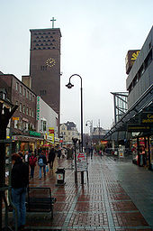
There are three pedestrian zones and a forum in Wiesdorf . Other cultural institutions are the Wiesdorf Citizens' Hall, the topos, the Erholungshaus and Kinopolis. In the Neuland-Park , also called "LaGa" (formerly the state horticultural show area), there are z. B. mini golf, a water playground and climbing equipment.
Sports
The Taekwondo Budoverein Wiesdorf e. V. offers Taekwondo with a wide range of self-defense training.
Attractions
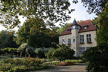
The Doktorsburg , a former manor built in 1682, is worth seeing . The building was once a moated castle. It is named after the academic degree of Dr. Jakob von Omphal, who bought the property in 1540. It was previously owned by Abraham Schaaffhausen . In the 1930s, the Doktorsburg was to be converted into a local museum. The work that had already started, however, had to be broken off by a decree by the Reich and Prussian Ministers for Science, Education and National Education.
The Colony Museum is located in one of the listed buildings of the former Bayer factory estates . It is decorated with original furniture and objects from the 1920s and 30s and shows the everyday life of factory workers and their families during this period.
Another of Wiesdorf's attractions is the Japanese Garden, which, however, is already in the area of the city of Cologne. It was created in 1913 and significantly expanded by Carl Duisberg after a trip around the world. In 1960 the garden was moved 200 meters further north to its current location. It has an area of about 15,000 square meters.
Infrastructure and facilities
- City Hall Gallery
- library
- St. Josef Hospital
- OT youth center Hindenburg bunker
- Streetwork contact point
- Neuland-Park am Rhein (the area of a landfill used by Bayer AG from 1923 to 1965 was re-presented as a park for the 2005 State Garden Show)
education
- Study center of the Fernuniversität Hagen
- Catholic day care center
- Red Cross Kindergarten Erholungshauspark
- Municipal kindergarten
- Community elementary school Dönhoffstraße
- Catholic primary school Dönhoffstrasse
- Realschule Am Stadtpark
- Lise Meitner High School
- Municipal vocational college for business and administration
- Vocational training center Leverkusen of the Cologne Chamber of Industry and Commerce V.
- Geschwister-Scholl-Schule - Municipal vocational college for technology, housekeeping and social education
- music school
- Community College
traffic
- Leverkusen Mitte train station
- Leverkusen Chempark S-Bahn station (officially located in Cologne city area)
- Bus station
additional
The Church of St. Maria Friedenskönigin , built in 1955, was deconstructed in 2006.
Sons and daughters
- Roland Kollmann (1935–2014), Roman Catholic theologian
- Klara Stoffels (1904–1944), Jehovah's Witness, executed in Plötzensee
literature
- Adolf Horst: Wiesdorf, Bayer und die Kolonien , Leverkusen - Development of a City, publisher. Citizens' Association Colony II and II Wiesdorf / Manfort, Leverkusen 1986
- Franz Greeting: Leverkusen. History and stories . Verlag Anna Gruß, Leverkusen 2003.
- Leverkusener Informations 2004, publisher: City of Leverkusen, Leverkusen 2004.
- City archive (ed.): Leverkusen. History of a city on the Rhine . Publishing house for regional history, Bielefeld 2005.
Individual evidence
- ↑ Wiesdorf in numbers. Retrieved June 20, 2013 .
- ↑ Wiesdorf. (No longer available online.) Archived from the original on June 6, 2013 ; Retrieved June 20, 2013 . Info: The archive link was inserted automatically and has not yet been checked. Please check the original and archive link according to the instructions and then remove this notice.
- ↑ http://www.leverkusen.com/guide/index.php?view=00304
- ↑ http://www.leverkusen.com/denkmal/index.php?view=211
- ↑ Hans Martin Henning: The Far East in the bourgeois garden culture of the Weimar Republic: Carl Duisberg's Japangarten . In: Die Gartenkunst 13 (1/2001), pp. 109–118.
- ↑ http://www.leverkusen.com/guide/index.php?view=00053
- ^ Deutsche Bahn is renaming the S-Bahn station


