
Königsforst
Coordinates: 50 ° 55 ′ 57 ″ N , 7 ° 7 ′ 49 ″ E


The Royal Forest is a 2,519 hectare large wooded area east of Cologne . It is part of the Bergische Heideterrasse . The forest is a bird protection and FFH area . Parts of the forest belong to the nature reserve Königsforst (Cologne) and nature reserve Königsforst (Rhein-Berg) .
location


The 25 square kilometer forest area touches the area of the cities of Cologne , Bergisch Gladbach and Rösrath . In the north it is limited by the A 4 Cologne - Olpe motorway . In the south-west, the A 3 Cologne - Frankfurt and the Aggertalbahn ( KBS 459 ) cut through the area. A motorway exit of the same name makes the Königsforst accessible via the A3 motorway. The final stop at Königsforst on tram line 9 is right on the edge of the forest. The Wahner Heide nature reserve connects to the south .
The Königsforst is the largest contiguous forest area on the Middle Terrace on the right bank of the Rhine . The highest point is the Tütberg at 212 m above sea level. NHN . The border of the Cologne city area runs through the Königsforst. On it lies Cologne's highest point, the Monte Troodelöh with a height of 118.04 m above sea level. NHN .
history

Numerous barrows between Cologne-Rath and Forsbach testify to an Iron Age settlement of the area. You will be part of the Hallstatt culture of the 6-7 Century BC Assigned. After the systematic excavations around 50 years ago, the burial mounds are barely recognizable. The finds can be found in the Roman-Germanic Museum .
Originally, the royal forest was a forest that was part of the crown property of the Franconian kings. In the 10th century, Emperor Otto the Great bequeathed the royal forest to his brother Brun , the Archbishop of Cologne. The first documentary mention comes from the year 1003 AD, in which the Archbishop Heribert of Cologne left a quarter of the royal forest to the Deutz monastery . Two other quarters were owned by the St. Pantaleon Monastery in Cologne . The last quarter belonged to Archbishop Bruno of Cologne.
In the 12th century the area came increasingly under the control of the Counts of Berg. The old castles and knight seats in Bensberg, Refrath ( Motte Kippekausen ) and Forsbach ( Motte Beienburg ), which were initially built in the peripheral areas, bear witness to this .
The dukes of Berg used the forest as a hunting area. It was not until 1790 that the enormous number of red deer was reduced, which prevented the forest from regenerating and devastated some fields. Around 4,000 deer were shot that year.
With the secularization , the royal forest, which had been owned by the church until then, came into state ownership of the Grand Duchy of Berg . During the Napoleonic occupation the royal forest was almost devastated. The strong oaks were felled and shipped to France as timber.
With the Congress of Vienna in 1815, the “royal forest Königsforst” became Prussian . A scheduled reforestation began, mainly with alien pine trees. This reforestation continued for a long time and, after appropriate purchases, also included agricultural land such as Gut Schwiegelshohn .

In the Second World War, the Königsforst served as a military area and was largely closed to the population. There was an ammunition factory on the site of today's children's village. From here a track led to Bensberg station on the Cologne-Mülheim-Lindlar railway line . In the forest you can still find the concrete walls of former bunkers and the foundations of the signal systems of the Ostheim air base .
The Königsforst used to be looked after by the Königsforst Forestry Office in Bergisch Gladbach. Due to a reorganization of the forest offices, the regional forest office Rhein-Sieg-Erft, based in Eitorf, is now responsible for the state forest in the forest office district Bergisches Land. The long-term goal of forestry is to reintroduce the local deciduous trees. Since over 40,000 trees (mostly conifers) had to be felled due to illness in the first half of 2020, this long-term project could be accelerated.
Localities
In the Königsforst there were and are inhabited places. With industrialization , a gradual de-settlement began, which more and more led to the decline of individual buildings. In the 1960s, the tax authorities acquired the entire Königsforst and from then on ensured that the old empty houses were torn down or burned down. The following overview shows the individual localities.
| No. | Locality | district | city | still there? |
|---|---|---|---|---|
| 1 | Forsbach train station | Bockenberg | Bergisch Gladbach | No |
| 2 | Fahnberg | Bockenberg | Bergisch Gladbach | No |
| 3 | Large book wood | Untereschbach | Overath | Yes |
| 4th | Wood | Bockenberg | Bergisch Gladbach | No |
| 5 | Klein Buchholz | Moitzfeld | Bergisch Gladbach | partly yes |
| 6th | Röttgen | Moitzfeld | Bergisch Gladbach | No |
| 7th | Mockery | Bockenberg | Bergisch Gladbach | No |
| 8th | Stone house | Bockenberg | Bergisch Gladbach | Yes |
| 9 | Tütberg | Bockenberg | Bergisch Gladbach | Yes |
Mining

In the entire Königsforst mining has been carried out in many places in the Bensberg ore district . On the northwestern edge the mines were mine Galilei and pit Julien , as well as on the northeastern edge in the later federal highway 4 the pit Leopold von Buch and the pit Felix . In the western Königsforst there were the mines Grube Copernicus , Grube Königsforst , Grube Löwenherz and Grube Quirin . In the center of the Königsforst were the mines Grube Blondel , Grube Carlsglück , Grube Deutscher Michel , Grube Direktion Elberfeld , Grube Segen Gottes and Grube United Glückauf . In the eastern Königsforst there were the mines Grube Grünewald , Grube Henricus , Grube Klaproth , Grube Napoleon and Grube Victor . The former Grünewald mine was last used by the Lüderich mine to deposit the sludge from the flotation plant here. Finally, there was am Rather way at the beginning of Paffrather Kalkmulde around the Children's Village Bethany the pit Consolidierte Catharina II .
Protected area
.jpg)
Large parts of the Königsforst belong to the bird protection and FFH area Königsforst under the entry Natura 2000 no. DE-5008-401 by the State Office for Nature, Environment and Consumer Protection North Rhine-Westphalia . The presence of the middle woodpecker is decisive for this protection . The bird species kingfisher , gray woodpecker , black woodpecker and honey buzzard are also protected .
In addition, the Königsforst in the Rheinisch-Bergisches Kreis is under key no. GL-038 with 1572.81 hectares and in the city of Cologne under the key no. K-020 with 988.63 hectares designated as a nature reserve. In addition, the Großer Steinberg natural forest cell was designated as a natural forest cell as part of the Königsforstes .
See also
- Königsforst nature reserve (Rhein-Berg)
- Königsforst nature reserve (Cologne)
- Großer Steinberg natural forest cell
- List of nature reserves in the Rheinisch-Bergisches Kreis
- List of nature reserves in Cologne
Local recreation destination for the population
The Königsforst is a popular local recreation destination. The population likes to go hiking, running, riding and cycling, especially on the weekends. A well-developed and marked network of trails, including a section of the Way of St. James , offers a wide range of options.
Those who do not have a hiking map can find their way around on an explanatory board at the hiking car park near the BASt . From here two circular hiking trails are marked with a duration of 75 minutes and two hours respectively.

There was once a Porz-Königsforst station on the Aggertalbahn . Here excursionists looking for relaxation got off and on. In the early 1980s the station was abandoned. The station building, built in 1890, was converted into the Waldhaus Königsforst excursion restaurant . The restaurant has been called Asado since 2006 .
Forest nature trail
Those who head for the forest on tram line 9 via the Rath / Heumar district of Cologne have the opportunity to follow an educational forest trail that starts at the nearby Rath Forsthaus and takes about an hour. On the four-kilometer circular route, the interested hiker gets a good insight into the diversity of the forest. 31 signs along the way explain the species-rich tree population.

|
|
Soil nature trail
At six stations, display boards explain the soil profiles revealed by the excavation.
| station | Soil type | geology | Water conditions |
|---|---|---|---|
| 1 | Gley - brown earth | Drift sand ( Pleistocene ) | Influence of groundwater at a depth of 80 to 130 cm |
| 2 | Pseudogley | sandy-loamy floating earth (Pleistocene) over clay ( Tertiary ) | strong waterlogging |
| 3 | Brown earth pseudogley | Fluid earth from weathered clay (Pleistocene) over older fluid earth from sandstone rubble (Pleistocene) over sandstone ( Lower Devonian ) | Waterlogging at a depth of 10 to 45 cm |
| 4th | Pseudogley brown earth, weakly podsolic | sandy floating earth (Pleistocene) over sandy-gravel main terrace (Pleistocene) over clay (Tertiary) | Waterlogging at a depth of 50 to 70 cm |
| 5 | Brown earth podsol | sandy-gravelly flowing earth (Pleistocene) over gravelly sand, fine sand and clay (Tertiary) | Apart from the slight influence of waterlogging in the lower section of the profile (in winter), the soil is free of backwater |
| 6th | Fen | Low bog peat ( Holocene ) over loamy-sandy stream deposits (Holocene) and floating earth (Pleistocene) | Groundwater extends to the surface of the terrain |
On the forest car park on Bensberger Straße, shortly before the entrance to Forsbach, an overview map provides information about the location of the six stations on the soil educational trail.
Brück game reserve
In the north-western part of the Königsforstes ( Brücker Hardt ) is the 50 hectare game reserve.
Here, visitors can in large enclosures red deer and wild boar observed.
Old railway line

The Cologne-Mülheim – Lindlar railway line (commonly known as the Sülztalbahn) ran from Cologne-Mülheim via Bergisch Gladbach and Bensberg to Rösrath and on via Hope Valley to Immekeppel and Lindlar . The section through the Königsforst between Bensberg and Rösrath was closed in 1961, the track systems were dismantled by 1964. Today the route is used as a cycling and hiking trail . The Forsbach train station in the middle of the Königsforst, built in 1890, was used as a residential building until the 1970s after the line was closed and then demolished. Today only a bronze plaque reminds of this train station in the Königsforst.
Imperial oak

About 500 meters west of the former Forsbach train station, at a crossroads, you will find the Imperial Oak . This designation is incorrect in two respects. On the one hand, it was only planted 20 years after the death of the popular emperor Wilhelm I. The reasons for this lie in the behavior of Kaiser Wilhelm II , a grandson of Wilhelm I, who knew how to use the grandfather's popularity for himself and suggested monuments for his predecessor. A monarch's wish is like an order to his subjects. And so in 1908, in memory of Kaiser Wilhelm I (1797–1888), the original imperial oak was planted in the Königsforst; it served French occupation soldiers as a target for target practice after the First World War. The oak did not survive that. On the opposite side of the path, however, there was another tree of this type, which has since been considered an imperial oak.
Run away
The Rennweg is an asphalt path that is particularly popular with cyclists and crosses the Königsforst in a north-south direction.
Waters in the Königsforst


In the middle of the Königsforst, exactly at the point where the three urban areas of Cologne, Bergisch Gladbach and Rösrath meet, there is a water step. Here the Giesbach is dammed in a basin. The healing effects of the cold water were already recognized by Antonius Musa, the personal physician of the Roman emperor Augustus . Musa prescribed cold baths for his prominent patient. This gave the gout-afflicted relief. Sebastian Kneipp had his patients walk through a water treading basin at a stork pace. You take turns submerging one foot in the water while the other remains outside. After the bath, the water is only shaken off, not dried off. After you have put your stockings and shoes on again, hiking or running will ensure adequate blood circulation and warming.
The Flehbach with its source and tributaries Böttcher Bach , Holzerbach , Wahlbach , Kleiner Wahlbach and Sellbach drains the Königsforst in a westerly direction.
The two-part Kettners pond is created by a backwater in the Wahlbach just before it flows into the Böttcherbach . There are benches to linger and a refuge. However, hikers can only see the lower part of the pond. The slightly higher eastern part is not accessible due to the densely wooded dam and the lack of paths.
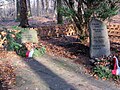
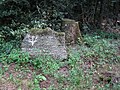
Memorial stones
In the Königsforst, memorial stones remember people who had something to do with the forest area.

Atonement Cross on Brüderstraße (1636)
Grave of Josef Hausmann (1874–1932)

Memorial HOA Memorial stone for "Hubertus O. Arntzen", whose body was found here.
Ferdinand Schwamborn, the exemplary supervisor of the Tütberg , 1914–1963

Christian Siebertz (1898–1928)


literature
- The Königsforst - history and stories (= workshop for local history [Hrsg.]: Series of publications of the workshop for local history Cologne-Brück eV Volume 12 ). 2nd Edition. Cologne-Brück 2011, ISBN 978-3-931291-12-9 .
- Hermann Josef Roth (ed.): Cologne nature guide. Wienand-Verlag, Cologne 1991, ISBN 3-87909-205-2 .
- Holger M. Sticht: Nature and culture guide Königsforst. Gaasterland Verlag, Cologne 2007, ISBN 978-3-935873-20-8 .
- Georg Sturmberg: 1000 years of the Königsforst - 1000 years of the forest without a king. From manor to nature reserve - a forest with a long tradition. In: Rheinisch-Bergischer Calendar . 2003, Heimatjahrbuch für das Bergisches Land, ISBN 3-87314-377-1 , pp. 6-19.
Web links
- Monte Troodelöh accessed on January 20, 2013
- Soil nature trail PDF, 3.3 MB, accessed June 5, 2016
- Bündnis Heideterrasse, accessed on January 20, 2013
Individual evidence
- ↑ Query of the course book route 459 at Deutsche Bahn.
- ↑ Peter Schönfeld: The motte and the knight seat Forsbach. One of the oldest medieval settlements in the Königsforst. , Rheinisch Bergischer Calendar 2015, Bergisch Gladbach 2014, pp. 20–27
- ^ Website of the State Office for Forest and Wood NRW (RFA Rhein-Sieg-Erft). Retrieved April 12, 2013 .
- ↑ In the Königsforst 43,000 trees had to be felled. Retrieved July 18, 2020 .
- ↑ Herbert Nicke : Tütberg, An example for the downfall of a settlement area, in: Forsbach, from the life of a village between Königsforst and Sülztal. (= Series of publications of the history association Rösrath eV Volume 26). Rösrath 2004, ISBN 3-922413-39-X , p. 207 ff.
- ^ Herbert Stahl (editor), Gerhard Geurts , Herbert Ommer : Das Erbe des Erzes. Volume 2: The pits in the Gangerz deposits in the Bensberg ore district. Cologne 2004, ISBN 3-00-014668-7 .
- ↑ Herbert Stahl (Ed.): The legacy of the ore. Volume 5: New news and stories about the Bensberg ore district . Bergisch Gladbach 2014, ISBN 978-3-00-044826-3 , p. 17 ff.
- ^ Herbert Ommer: mining relics in the royal forest . In: Mining in the Bergisches Land, examples of mining traces between Sülz and Wahnbach (= series of publications by the history association Rösrath eV Volume 32 ). Rösrath 2002, ISBN 3-922413-52-8 , p. 189 ff .
- ^ Herbert Stahl (editor), Gerhard Geurts, Hans-Dieter Hilden, Herbert Ommer, Siegfried Raimann: Das Erbe des Erzes. Volume 4: The Lüderich. Bergisch Gladbach 2008, ISBN 978-3-932326-52-3 .
- ^ Herbert Stahl (editor), Gerhard Geurts, Hans-Dieter Hilden, Herbert Ommer: Das Erbe des Erzes. Volume 3: The pits in the Paffrath Kalkmulde. Bergisch Gladbach 2006, ISBN 3-932326-49-0 .
- ↑ Natura 2000 areas in North Rhine-Westphalia , accessed on January 20, 2013.
- ^ "Königsforst" nature reserve in the specialist information system of the State Office for Nature, Environment and Consumer Protection in North Rhine-Westphalia , accessed on February 21, 2017.
- ^ "Königsforst" nature reserve in the specialist information system of the State Office for Nature, Environment and Consumer Protection in North Rhine-Westphalia , accessed on February 21, 2017.
- ↑ Overviews of the areas of the NWR - as of June 14, 2018
- ↑ HOA (memorial stone)