
MacDonnell Ranges
| MacDonnell Ranges | ||
|---|---|---|
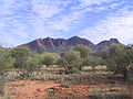
 View over the West MacDonnell Ranges from the Larapinta Trail near Glen Helen |
||
| Highest peak | Mount Liebig ( 1524 m ) | |
| location | Northern Territory ( Australia ) | |
|
||
| Coordinates | 24 ° S , 133 ° E | |

The MacDonnell Ranges are a 644 km long mountain range in the Northern Territory of Australia . They consist of parallel mountain ridges made of red sandstone that run west and east of Alice Springs . Mount Liebig at 1,524 m and Mount Zeil at 1,510 m are the highest peaks.
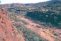
In numerous places the mountain ranges of deep-cut and sometimes only a few meters wide are cuts breached, whose most famous Simpsons Gap , Standley Chasm , Serpentine Gorge and Glen Helen Gorge count.
The mountain range was discovered by John McDouall Stuart in 1860 and named after Sir Richard MacDonnell , the then governor of South Australia .
The MacDonnell Ranges are home to numerous sites of the Arrernte , the local Aboriginal people . A 223 km hiking trail, the Larapinta Trail , runs through West MacDonnell National Park .
Web links

Aerial view of Alice Springs that a ridge of the MacDonnell Ranges and the severing Heavitree Gap shows
Mount Sonder (1,380 m)
Palm Valley
Ormiston Pound
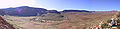
Ormiston Pound with Ormiston Gorge

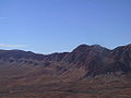
Mount Giles (1,389 m)

Alice Springs


