Machnower See (Rangsdorf)
| Machnower See | ||
|---|---|---|

|
||
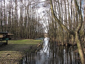
| Drainage (Zühlowgraben or Schustergraben) of the Machnower See at the fishing house of the Groß Machnow fishing club | ||
| Geographical location | Germany , Brandenburg | |
| Tributaries | Zülowgraben | |
| Drain | Zülowgraben → Zülowkanal → Nottekanal → Dahme | |
| Places on the shore | Rangsdorf | |
| Location close to the shore | Great Machnow | |
| Data | ||
| Coordinates | 52 ° 16 ′ 41 ″ N , 13 ° 26 ′ 56 ″ E | |
|
|
||
| Altitude above sea level | 35.8 m above sea level NN | |
| surface | 8 ha | |
| Maximum depth | 0.50 | |
The Machnower See , also Groß Machnower See , formerly also called Praden or Proden , is a small, heavily silting lake at the southern end of the municipality of Rangsdorf , Brandenburg , or west of Groß Machnow (district of Rangsdorf). It forms the core of the Machnower See nature reserve .
Location and characteristics
The Machnower See lies exclusively on Groß Machnower Markung, but the southern foothills of the core town of Rangsdorf in the west come closer to the lake than the eponymous district of Groß Machnow east of the lake. To the southwest of the lake lies the Pramsdorf residential area on the Groß Machnower district , a village that was independent from the Middle Ages to the early modern period. The lake is heavily silted up and today has two separate bodies of water, the size of which is now given as four to eight hectares. In 1903 the lake still had a size of 19.8 hectares. Its depth was given as four meters. In 2011 the depth was given as only 50 cm. The Zülowgraben flows into the lake from the north and drains it in the southeast to the Zülow Canal.
The lake lies in an ice age meltwater channel that ran from the north of the Teltow into the Notte lowlands. The lake level fluctuates around 50 cm. When the water levels are high, the forests that surround the lake are flooded.
history
The Machnower See used to be called Proden or Praden. This name is still used today in the name of the neighboring Pramsdorf. In the first documented mentions (1375) the place was called Prodensdunk , Prodensdunck or Prodenstorff . The name Praden is either of Slavic origin or it is a transferred name from Dutch.
In the 1930s there were plans to expand Machnower See into a seaside resort. A train station was planned near Pramsdorf. The site was to be built on from Pramsdorf (Pramsdorfer Weg) along the railway line and Lake Machnower to Rangsdorf with a "country house colony". The plans came to nothing. A gravel pit was later dug along the railway line, which today forms the Rangsdorf Kiessee .
use
The Machnower See is the core of the Machnower See nature reserve . The bank areas are inaccessible. The lake area can only be reached through the drainage channel at the fishing hut. The Machnower See is currently used for fishing by the Groß Machnow fishing club.
In order to stop the silting up of the lake, the municipality of Rangsdorf applied for three million euros from the funds made available for the construction of the Berlin Brandenburg International Airport in Schönefeld for compensatory measures for interventions in the environment. The funding application was rejected in December 2010. However, the nature conservation fund made it clear that this is not a final rejection, but that the project should only be tackled when the municipality of Rangsdorf has taken suitable measures to retain nutrients that are carried from the Zülowgraben into the Machnower See. The heavy loading of nutrients in the Zülowgraben is the main cause of the current rapid silting up of the lake.
See also
Individual evidence
- ↑ www.deutschland-angeln.de ( page no longer available , search in web archives ) Info: The link was automatically marked as defective. Please check the link according to the instructions and then remove this notice.
- ↑ Statistical yearbook of the Teltow-Fläming district 2006 from 2007 (PDF; 849 kB)
- ^ Eckstein, Karl: 2. The fishing conditions in the province of Brandenburg at the beginning of the 20th century. The waters of the province of Brandenburg in alphabetical order and their fishing conditions. 275 S., Berlin 1908 [1] (snippet view in GoogleBooks)
- ↑ General display for Rangsdorf, Groß Machnow and Klein Kienitz, February 12, 2011 No. 2 - 15th year - 6th week, p. 4 PDF ( page no longer available , search in web archives ) Info: The link was automatically defective marked. Please check the link according to the instructions and then remove this notice.
- ^ Gerhard Schlimpert: Brandenburg name book part 3 The place names of the Teltow. 368 p., Hermann Böhlaus successor, Weimar 1972.
- ↑ Heidi Kansy: Groß Machnow - A contribution to local history, part 2. 64 p., Community Groß Machnow, 2003 (p. 25)
- ↑ Machnower See: No airport funds for renovation (notification of December 10, 2010)
- ↑ Nature conservation fund does not want to approve money for the renaturation of Lake Machnower until a few years from now ( page no longer available , search in web archives ) Info: The link was automatically marked as defective. Please check the link according to the instructions and then remove this notice. (Märkische Allgemeine: message from December 17, 2010)

