
Main Beach (Queensland)
| Main Beach | |||||
|---|---|---|---|---|---|
 Beach houses |
|||||
|
|||||
|
|||||
|
|||||
|
|||||
|
|||||

Main Beach (formerly Southport East ) is a suburb of the Gold Coast city in Queensland , Australia . During the 2011 census, 3,883 people lived in the place.
geography
The boundaries of Main Beach are defined by a dune between the sea and the Nerag River to the north. At the mouth of the river is a natural basin for boats.
history
During the years when Southport was the hub of coastal activity, visitors were taken on a ferry across Broadwater to surf on Main Beach. The first holiday homes were built in 1926. Since the beach was the most important surfing beach in all of Southport, it was named "Main Beach".
The construction of the Sundale Bridge and the junction of the freeway in West Main Beach in the late 1960s made the suburb even more accessible. The bridge spans the Nerang River, connecting the suburbs of Southport and Main Beach. After the bridge was built, Main Beach became more and more popular. Now there are numerous hotels or amusement parks along the beach.

Main Beach at low tide

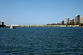
View north to Southport (2007)
Sundale Bridge


Web links
- University of Queensland: Places in Queensland: Main Beach
- Main Beach Progress Association Official Site
Individual evidence
- ↑ a b Australian Bureau of Statistics : Main Beach ( English ) In: 2016 Census QuickStats . June 27, 2017. Retrieved April 14, 2020.