
Makerua Swamp

The Makerua Swamp ( German : Makerua-Sumpf), also the Opiki Plains (German: Opiki-level), in the Opiki district of the Manawatu-Wanganui region of New Zealand was the center of the cultivation of New Zealand flax around 1910 . There were numerous flax mills along the Manawatu River . Flax fiber was an important export product from New Zealand.
geography
The Makerua Swamp originally extended in the coastal plain of Palmerston North , which is to the west of the Tararua Range , along the Manawatu River on the North Island of New Zealand. Today the area belongs to the places Opiki , Tokomaru , Moutoa and Shannon . Between hills that delimit the plain to the west and the Tararura Range to the east, the flat, low-lying plain extends in which the river runs in wild meanders . In the east the Tokomaru River , whose tributaries come from the Tararua Range, forms the border of the swamp. Other rivers are Kara River , Mangaore, and Koputaroa . From Moutoa ( ⊙ ) the river makes a wide curve to the south before it flows into South Taranaki Bight at Foxton Beach . To the northwest of Moutoa, however, there is a flood canal for flood regulation, which shortens this arch. Today the area is largely arable and used for agriculture. At Mukapai in the Tokomaru area there is another small area with an area of 45.2 hectares ( ⊙ ) that is under nature protection.
Flax mills
In the Makerua Swamp, many flax mills existed on the banks of the Manawatu River in the early 20th century. Flax fibers from New Zealand flax ( New Zealand hemp, New Zealand flax ; Harekeke ; phormium tenax ) were an important export good from New Zealand.
The Miranui Flax Mill at Shannon ( Great Mill in Maori ) was in operation from 1907 to 1933 and was the largest flax mill in the area. At its peak, it had seven flax breaking machines and 300 employees.
traffic
National Road 56 crosses the swamp, while National Road 57 runs along the southern border at the foot of the Tararua Range.
railroad
._Palmerston_North_City_Library,_digitisation_ID_2007N_Fx91_FLA_0636.jpg)
The Miranui Flax Mill also maintained the Miranui Flax Tramway , a 5.6 km long light railway with a track width of 3 feet (914 mm) Since the engine was too heavy for the swampy terrain, from horse-drawn Loren were used in 1910.
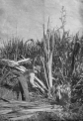
A worker harvests the green leaves
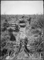
Loading of the flax on light rail trucks

A worker loads a Flax stripper
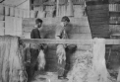
Two workers brushing the flax

Flax bales for removal
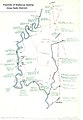
Flax factories map
.png)
.png)
.png)
.png)
.png)

literature
- Bob Ayson: Miranui - The Story of New Zealand's Largest Flax Mill. 1977.
Web links
Individual evidence
- ↑ Ian Matheson: Flaxmills of Makerua Swamp. 1978, Palmerston North Libraries and Community Services.
- ^ Albert Percy Godber: Bales of flax fiber ready for market AP Godber Collection, Alexander Turnbull Library. Reference Number: APG-1438-1 / 4-G.
- ↑ a b c George Leslie Adkin (1888–1964): Loading cut flax in Makerua. In: Photographs of New Zealand geology, geography, and the Maori history of Horowhenua. Ref: 1 / 2-065689-G. Alexander Turnbull Library, Wellington, New Zealand.
- ↑ Ian Matheson: Flaxmills of Makerua Swamp. 1978, Palmerston North Libraries and Community Services.
- ↑ geonames.org .
- ^ New Zealand Department of Conservation (ed.): CMS - Conservation Management Strategy . Volume III Maps . Wellington 2019, ISBN 978-1-988514-85-7 , pp. 33 (English, online [PDF; 24.0 MB ; accessed on September 21, 2019]).
- ^ Albert Percy Godber: Bales of flax fiber ready for market AP Godber Collection, Alexander Turnbull Library. Reference number: APG-1438-1 / 4-G.
- ↑ Malcolm McKinnon: Manawatū and Horowhenua region - Human impact on the environment . Te Ara - the Encyclopedia of New Zealand. Retrieved May 6, 2018.
- ^ A b Catherine Knight et al: The little engine that couldn't: the Miranui tramway. Published March 17, 2012. Retrieved May 6, 2018.
Coordinates: 40 ° 30 ′ 30 ″ S , 175 ° 26 ′ 25 ″ E