Malargüe

|
||
| Basic data | ||
|---|---|---|
| location | 35 ° 28 ′ S , 69 ° 35 ′ W | |
| Height above d. M .: | 1416 m | |
| Population (2001): | 18,077 | |
|
|
||
| administration | ||
| Province : |
|
|
| Department : | Malargüe | |
| Others | ||
| Postal code : | M5613 | |
| Telephone code: | +54 (0) 2627 | |
| Malargüe website | ||
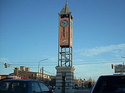
Malargüe (pronunciation: [ maˈlarɡuɰe ]) is a city in the department of the same name (18,077 inhabitants, INDEC 2001) in the south of the province of Mendoza in Argentina . It is located about 420 kilometers south of Mendoza and 180 km southwest of San Rafael . Gravel roads lead south ( Chos Malal ) and over the Paso el Pehuenche to Talca in Chile .
Malargüe is the location of the Pierre Auger Observatory for research into ultra-high energy cosmic rays and the location of a 35 m antenna of ESA's own ESTRACK deep space network.
The Notocolossus was discovered in the area in 2013 .
climate
|
Average monthly temperatures and rainfall for Malargüe
Source: Servicio Meteorológico Nacional
|
|||||||||||||||||||||||||||||||||||||||||||||||||||||||||||||||||||||||||||||||||||||||||||||||||||||||||
Web links
Commons : Malargüe - collection of images, videos and audio files
- Malargüe website (English / Spanish)
- LiveArgentina.com - City Info (Spanish)
- Pierre Auger website
- Las Leñas website
