Mandol
| Mandol District | |
|---|---|
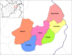
 Districts of Nuristan Province; Salmon colored mandol |
|
| Basic data | |
| Country | Afghanistan |
| province | Nuristan |
| Seat | Mandol |
| Residents | 23,000 (2003) |
| ISO 3166-2 | AF ONLY |
Coordinates: 35 ° 24 ' N , 70 ° 18' E
Mandol is the western district of the Afghan province of Nuristan .
Geographical location
It is bounded in the north by the Badakhshan province (borders here on the Kuran va Munjan district ), in the west by the Panjshir province and in the south by the Laghman province . The eastern border is represented by the Nuristan and Wama districts . Mandol is primarily characterized by the course of the Alingar and its tributaries. The north-south extension is approx. 80 km and the east-west extension is approx. 65 km. Almost 50% of the district is permanently covered by snow, vegetation can only prevail in the valleys in the south of Mandol. The lowlands are at an altitude of about 2500 m , while the peaks of Mandol easily reach 3500 m . The administrative headquarters are in Mandol . According to UN statistics from 2003, around 23,000 people live in the Mandol district.