
Punjjir
|
پنجشیر Punjjir
|
|
|---|---|
  |
|
| Basic data | |
| Country | Afghanistan |
| Capital | Bazarak |
| surface | 3610 km² |
| Residents | 153,500 (2015) |
| density | 43 inhabitants per km² |
| founding | April 13, 2004 |
| ISO 3166-2 | AF-PAN |
| politics | |
| governor | Keramuddin Keram |
 |
|
Coordinates: 35 ° 30 ' N , 70 ° 0' E

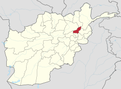
Panjshir Province (also Panjshir or Panjshar ; persian پنجشیر Panjshir , DMG Panǧšīr , 'five lions', Pashtun پنجشېر Panjsher ) is one of the 34 provinces of Afghanistan .
It was established on April 13, 2004. The province itself, however, goes back to a millennium long history. The population is about 153,500 and the province extends over 3610 km². The administrative seat is in Bazarak . Dari is the main spoken language in Punjjir and the majority of the inhabitants are Tajiks . The province is located about 100 km northeast of Kabul .
Ahmad Shah Massoud , known as "the Lion of Punjjir", was a famous Afghan general who was murdered on September 9, 2001 by suicide bombers . He organized the defense of the valley during the Soviet-Afghan war until the withdrawal of the Soviet army . In the civil war that followed, the Taliban were never able to take Punjjir.
geography
The province is shaped by the eponymous river Pandschir , which cut the narrow Pandschir valley deep into the surrounding mountains of the Hindu Kush. The province extends over the catchment area of the Punjjir above the city of Golbahar . An important trunk road runs through the Punjir Valley. It connects the capital Kabul with the northeastern province of Badachschan .
Administrative division
The Punjjir Province is divided into 7 districts:
- Bazarak - Lower Punjir Valley between Khenj and Rukha
- Dara - catchment area of a left Punjjir tributary in the southeast
- Khenj - middle section of the Punjir Valley
- Onaba - lower Punjjir valley between Shotol and Rukha
- Pariyan - the upper section of the Punjir Valley in the north
- Rukha - lower Pandschir valley between Onaba in the south and Bazarak in the north
- Shotol - Shotol river valley in the southwest and the lowest section of the Punjjir valley
A map of the districts can be found on the Library of Congress website.
Web links
Individual evidence
- ^ Afghanistan. In: citypopulation.de. Retrieved January 8, 2016 .
Badakhshan | Badghis | Baglan | Balkh | Bamiyan | Chost | Daikondi | Juzjan | Farah | Faryab | Ghazni | Ghor | Helmand | Herat | Kabul | Kandahar | Kapisa | Kunar | Kunduz | Laghman | Lugar | Nangarhar | Nimrus | Nuristan | Paktia | Paktika | Punjjir | Parwan | Samangan | Sar-i Pul | Tachar | Urusgan | Wardak | Zabul