Kuran va Munjan
| Kuran district va Munjan | |
|---|---|
 Location of Kuran va Munjan in the Badakhshan Province |
|
| Basic data | |
| Country | Afghanistan |
| province | Badakhshan |
| Seat | Waswarzu |
| surface | 4518 km² |
| Residents | 8000 (2007) |
| density | 1.8 inhabitants per km² |
| ISO 3166-2 | AF-BDS |
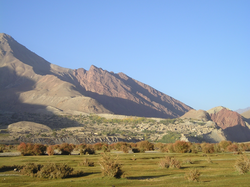
| View from the middle of the main valley to the western village | |
Coordinates: 36 ° 0 ' N , 70 ° 53' E
Kuran va Munjan also Koran va Monjan , (and also Kerān va Menjān, 'Alaqehdari-ye Koran va Monjan, Kerana va Manjah,' Alāqehdārī-ye Korān va Monjān, Keran va Menjan, Korān va Monjān, Koṟnomunjan der, south of the and after the Wakhan district the second largest district in the Afghan province of Badakhshan .
It has an area of around 4500 km². The main places are around 2500 to 2600 m high. The district borders in the north on the Badakshan districts of Tabak, Yamgan and Zibak, in the east on Pakistan , in the south on the Afghan province of Nuristan and in the west on the provinces Panjshir and Takhar . The settlement center of the district forms a high valley with a west-east extension of around 20 km and a width of 2 km, i.e. around 40 km², which makes up only around one percent of the total area of the district.
With less than 2 inh. / Km² Kuran va Munjan is on average very sparsely populated even for Badakhshan standards, whereby it should be noted that the population is max. Concentrated 2 to 3 percent of the arable area of the district. The vast majority of the district is over 3000 m above sea level and is uninhabited.
The two largest cities of the district are the location at the west end of the main valley village Warwarzu ( 36 ° 1 ' N , 70 ° 40' O ) and the village Segewaw in the center of the valley, wherein Warwarzu rather can be considered as an administrative center. There are also some smaller towns and scattered settlements in the main valley.
The southern part of the district consists of the Hindu Kush mountains, which are over 6000 meters high, in the valleys of which there are only a few smaller villages.
traffic
The district can be reached from the north via a gravel road. A difficult-to-drive slope runs towards the southwest towards Kabul . From the provincial capital Feyzabad to the main valley of Kuran va Munjan, an off-road vehicle takes around 24 hours to cover the 200 km route. The Razer airfield is located in the eastern main town , but it is only a gravel runway from the Soviet occupation. The runway is not operated and can only be reached via dirt roads. The river is a hindrance to traffic in the main valley and can only be crossed via fords, the route of which you have to find out from the locals beforehand. The village of Warwazu can also only be reached from the north via a ford. A comparatively good gravel road connects the two main towns south of the river. The airport north of the river can only be reached from Segewaw via a ford. In general, car traffic in Kuran va Munjan only plays a subordinate role.
Cultural institutions
There is a primary school roughly in the middle of the two main towns, Warwarzu and Segewaw. The Aga Khan Foundation has a branch in Warwazu .
economy
In Kuran va Munjan, agriculture is largely the only economic basis, whereby due to the climatic conditions, pasture farming dominates by far, while agriculture is only of certain importance for self-sufficiency in the gardens near the houses. There is a petrol station in Varwazu, whereby "petrol station", as usual in Badakhshan, is to be understood literally; It is a wooden crate with a few canisters of diesel, as well as small craft shops and dealers for daily needs. Overall, the poorly developed transport links are holding back the economy. The sometimes day-long transport routes by all-terrain trucks or donkey caravans make even the simplest raw materials more expensive. So are z. B. Wood or gasoline in Kuran va Munjan much more expensive than in Germany. In autumn 2009 there was z. B. only a truck that the Agha Kann Foundation had rented from outside.
climate
Due to the altitude, the climate is comparatively cool, with winters in particular being long, cold and snowy. In summer, on the other hand, it gets very hot during the day. The highest peaks in the Hindukush are glaciated.
Web links
Individual evidence
- ↑ Afghanistan Information Management Service (AIMS), on aims.org.af : Kuran wa Munjan District , January 2004 ( online ( page no longer available , search in web archives ) Info: The link was automatically marked as defective. Please check the link accordingly Instructions , then remove this notice. ), Accessed April 4, 2009
- ↑ Islamic Republic of Afghanistan Ministry of Transport and Civil Aviation - Razer Airport ( Memento of the original from February 13, 2009 in the Internet Archive ) Info: The archive link was automatically inserted and not yet checked. Please check the original and archive link according to the instructions and then remove this notice. , accessed April 5, 2009


