
Moroccan wall


Berm is the proper name, derived from Arabic, for the Moroccan sand wall in the Western Sahara , which separates the part of the area administered and controlled by Morocco from the so-called free zone , which is largely from the Polisario rebels or the government of the internationally only partially recognized democrats Arab Republic of Sahara (DARS) is controlled.
meaning
"With a largely mine-infested wall" the infiltration of rebels into the occupied areas since 1975 is to be prevented, whereby the fortification of the military-political function of the Morice line (Ligne Morice) equates to the French war in Algeria . From the Frente Polisario , the wall dividing the country is also known as the "Wall of Shame", in Morocco colloquially known as "Hassan's Wall" (after the former King Hassan II ).
View from the "Free Zone" to the wall north of Tifariti

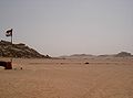
Wall south of Mahbes


The 2500 to 2700 kilometer long wall extends from the Moroccan- Mauritanian coastal border in the southwest to the Moroccan (Saharan) - Algerian- Mauritanian triangle in the northeast of the disputed area. To the north, the wall continues for a few hundred kilometers along the Moroccan-Algerian border.
The wall is about three meters high, mostly secured by land mines and barbed wire , only in places it consists of a wall or rubble. In part, mountainous terrain serves as a natural obstacle, but in places (especially in the southern areas) the wall is overlaid and eroded by large, significantly higher shifting dunes . At a distance of a few kilometers (usually 1–3 km), small groups of Moroccan guard soldiers are stationed in oval to arbitrarily designed camps. There are larger main camps about every 10 to 15 km.
The wall was built between 1980 and 1987. In several construction phases and military-political decision-making stages, more and more areas have been enclosed by the wall since 1982, at al-Hawza ( Es Semara province ) there was a small gap in the meantime. El Aaiún and most of the cities and towns are in the Moroccan zone, where over 90% of the approximately 597,000 inhabitants (2019 estimate) of the Western Sahara live. Nevertheless, Morocco also regards the barely populated desert areas of the "Free Zone" (30,000 inhabitants) lying outside the wall as its territory and the wall as an inner Moroccan security line, i.e. a demarcation line . The DARS also claims the entire area of Western Sahara, the future of the area divided by the wall still depends on an agreement between the conflicting parties under UN mediation.
See also
literature
- Said Saddiki: World of Walls: Structure, Roles and Effectiveness of Separation Barriers. Open Book Publishers, Cambridge 2017, sv Chapter 5: The Wall of Western Sahara , pp. 97–120
Web links
- Spiegel online , March 18, 1985: Modern Limes
Individual evidence
- ↑ Western Sahara - An ongoing conflict in the desert. In: Bundeswehr aktuell. November 6, 2013, accessed June 23, 2016 .
- ↑ Anne Vidalie: La "Grande Muraille" du Sahara, "mur de défense" ou "mur de la honte"? In: L'Express , August 11, 2017, accessed on January 21, 2020.
- ↑ Population of Western Sahara according to the United Nations Secretariat, Department of Economic and Social Affairs, Population Division: World Population Prospects 2019 , accessed on January 21, 2020.