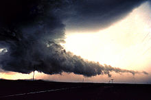
Wallcloud
A wall cloud is a more or less isolated depression under the low-precipitation updraft area of a shower or thundercloud ( cumulonimbus ), from which a tornado sometimes develops.

It is typically located below the precipitation-free area of the shower or thunderstorm cell and marks the area with the strongest updraft , which in the case of a super cell is typically located at the southern or southwestern end of the same. The wall cloud can be between a fraction of a kilometer and over 8 kilometers wide. Some wall clouds show a rotation, which is an indication of a rotating updraft, a mesocyclone . Such rotating wall clouds usually develop a few minutes to almost an hour before strong tornadoes and typically rotate cyclonally. Therefore, rotating wall clouds in particular are viewed as warning signs of tornadoes.
Development process
A wall cloud occurs because the condensation level (the cloud base) is locally reduced. This is usually due to the fact that moist air is also sucked from the precipitation area into the updraft area, which condenses out earlier when ascending. The wall cloud is therefore often inclined in the direction of the precipitation area. It is not uncommon for a so-called tail cloud , a narrow band of cloud fragments ( fractus ), that extends from the wall cloud to the precipitation and downdraft area behind it (see illustration on the right). This is also a sign that moist air from the precipitation area is being sucked in by the updraft.
Web links
- Wall cloud in the weather dictionary of the German Weather Service
- The life cycle of a tornado (English) at www.f5tornadosafaris.com (source)
- Explanations of supercells with schematic illustrations on the website of the Cooperative Institute for Mesoscale Meteorological Studies (English)
- Thunderstorm knowledge for Stormchaser, section on components of a thunderstorm at www.blitzwetter.de
