Mesocyclones

A mesocyclone (or: a mesocyclone ) is a rotating updraft field in a convective cloud .
Thunderstorm cells with long-range and long-lived mesocyclones are called supercells , this definition goes back to Charles A. Doswell . Mesocyclones in powerful thunderstorm cells and super cells usually have a diameter of between two and ten kilometers and usually rotate in a cyclonic direction .
Mesocyclones are part of mesoscale meteorology , which deals with weather systems with an extension of 2 to 2000 kilometers. They are mostly recognized with the help of Doppler radar systems. A meso-vortex is a similar rotating vortex, but it is usually smaller and weaker than a mesocyclone and is mostly associated with squall lines . Mesocyclones in super cells achieve a maximum vertical vorticity of 10 −2 .
Emergence
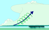
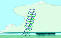
A mesocyclone can arise when there are large differences in wind speed and direction at different altitudes, this is known as wind shear . This creates horizontal circulations in the atmosphere. The convective updraft of a shower or thunderstorm cell can tip these eddies into a vertical position, which ultimately sets the entire updraft of the cell in rotation.
When the rotating updraft moist air from the front side downdraft (FFD, Forward Flank Down Draft) aspirates, one can Wallcloud arise, one below the cloud base of the updraft lowered, usually rotating cloud. A funnel cloud can form from the wall cloud ; this represents the first visible part of the tornado formation.
Occasionally, in addition to the cyclonally rotating main mesocyclone of a super cell, another updraft area forms in which convective clouds can form. This updraft area is carried away by the main mesocyclone and set in rotation, which leads to the formation of a so-called antimesocyclone, which rotates anticyclonally and can form an anticyclonally rotating tornado . Such anti-mesocyclones are usually much weaker than the (main) mesocyclones and move with them.
recognition
Mesocyclones can be detected and verified using Doppler radar. To do this, computers are used to check the relative wind speed data for unusually large differences. The German Weather Service uses this method in its daily weather warning service.
Mesocyclones are mostly located in the rear, right flank of a super cell or squall line . A mesocyclone of a super cell can lead to the formation of a hook echo on radar maps if the precipitation area is wrapped around them by the rotation of the low-precipitation mesocyclones. Visible features such as a rotating wall cloud or a tornado can also indicate the existence of a mesocyclone.
swell
- ^ A b Glossary of Meteorology: Mesocyclone . American Meteorological Society. June 2000. Archived from the original on July 9, 2006. Info: The archive link was automatically inserted and not yet checked. Please check the original and archive link according to the instructions and then remove this notice. Retrieved December 7, 2006.
- ↑ http://www.cimms.ou.edu/~doswell/Conference_papers/SELS96/Supercell.html
- ↑ a b Katharina Amstler, diploma thesis climatological-statistical elaboration of tornado events in Europe, p. 33
- ↑ http://www.wetterzentrale.de/cgi-bin/webbbs/wzarchive2004_3.pl?noframes;read=569397
- ↑ Katharina Amstler, diploma thesis climatological-statistical elaboration of tornado events in Europe, p. 29
- ^ University of Illinois. Vertical Wind Shear. Retrieved October 21, 2006
- ^ Glossary of Meteorology: Mesocyclone signature . American Meteorological Society . June 2000. Archived from the original on May 14, 2011. Info: The archive link was automatically inserted and not yet checked. Please check the original and archive link according to the instructions and then remove this notice. Retrieved February 1, 2010.
- ^ Thomas Hengstebeck, Kathrin Wapler, Dirk Heizenreder, Paul Joe: Radar Network-Based Detection of Mesocyclones at the German Weather Service . In: Journal of Atmospheric and Oceanic Technology . tape 35 , no. 2 , December 8, 2017, ISSN 0739-0572 , p. 299–321 , doi : 10.1175 / JTECH-D-16-0230.1 ( ametsoc.org [accessed March 25, 2019]).
Web links
literature
- Amstler, Katharina. (2011). Climatological-statistical processing of tornadoes in Europe. Diploma thesis, University of Vienna , meteorology


