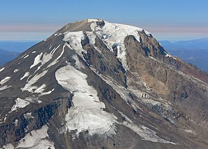
Mazama Glacier (Mount Adams)
| Mazama Glacier (Mazama Glacier) |
||
|---|---|---|
|
The Mount Adams with the Mazama Glacier (center front) |
||
| location | Yakima County , Washington , USA | |
| Mountains | Cascade chain | |
| Type | Kar glacier | |
| length | 1.77 km | |
| surface | 1.4 km² | |
| Altitude range | 3291 m - 2316 m | |
| Coordinates | 46 ° 10 ′ 49 ″ N , 121 ° 28 ′ 12 ″ W | |
|
|
||
| drainage | Hellroaring Creek → Big Muddy Creek → Klickitat River | |
| particularities | ends in a scree slope ; declining | |
The Mazama Glacier is located on the southeast slopes of Mount Adams , a stratovolcano in Washington state . At the same time it is part of the Yakama Indian Reservation . The glacier descends from about 10,800 ft (about 3,300 m) to about 7,600 ft (about 2,300 m). The Mazama Glacier was generally on the decline for over 100 years, losing about 46 percent of its area between 1904 and 2006.
Individual evidence
- ↑ a b TopoQwest (United States Geological Survey Maps). Mount Adams East, WA [map]. Retrieved November 11, 2012.
- ↑ Danielle Sitts, Andrew G. Fountain, Matthew J. Hoffman: Twentieth Century Glacier Change on Mount Adams, Washington, USA . (pdf) In: Northwest Scientific Association (Ed.): Northwest Science . 84, No. 4, 2010, pp. 378-385. doi : 10.3955 / 046.084.0407 . Retrieved November 11, 2012.
Web links
- Mazama Glacier ( English ) In: Geographic Names Information System . United States Geological Survey . Retrieved November 11, 2012.

